
- Home
- News
- Analysis
- States
- Perspective
- Videos
- Education
- Entertainment
- Elections
- World Cup 2023
- Features
- Health
- Business
- Series
- Economy Series
- Earth Day
- Kashmir’s Frozen Turbulence
- India@75
- The legend of Ramjanmabhoomi
- Liberalisation@30
- How to tame a dragon
- Celebrating biodiversity
- Farm Matters
- 50 days of solitude
- Bringing Migrants Home
- Budget 2020
- Jharkhand Votes
- The Federal Investigates
- The Federal Impact
- Vanishing Sand
- Gandhi @ 150
- Andhra Today
- Field report
- Operation Gulmarg
- Pandemic @1 Mn in India
- The Federal Year-End
- The Zero Year
- Premium
- Science
- Brand studio
- Home
- NewsNews
- Analysis
- StatesStates
- PerspectivePerspective
- VideosVideos
- Entertainment
- ElectionsElections
- Sports
- Loading...
Sports - Features
- BusinessBusiness
- Premium
- Loading...
Premium

What bringing back India’s ancient ports and harbours from the depths of time could mean

Ramesses II, an Egyptian pharaoh who was buried in 1213 BCE, had peppercorns in the nostril. The pepper, historians believe, might have gone from India. As a country with a vast coastline, today’s India was once a hub of maritime trade, having strong links with the East, the Middle East, Europe and Africa. The region once had innumerable ports. While a few have been located by...
Ramesses II, an Egyptian pharaoh who was buried in 1213 BCE, had peppercorns in the nostril. The pepper, historians believe, might have gone from India. As a country with a vast coastline, today’s India was once a hub of maritime trade, having strong links with the East, the Middle East, Europe and Africa. The region once had innumerable ports. While a few have been located by marine archaeologists, some lie submerged and others devastated due to changing tidal shifts and fluctuations in the sea. Underwater excavations, conducted by the National Institute of Oceanography, have brought to light the ruins of ancient harbours such as Dwarka, Bet Dwarka, Porbandar, Somnath, Vijaydurg, Sindhudurg and Poompuhar.
Also Read | The atlas of lost islands in a rapidly drowning world
A detailed study on ancient ports, harbours and jetties is the need of the hour. However, maritime excavations are quite expensive compared to terrestrial ones, a reason why a major share of our marine history remains unknown to people today. Even though only a few ancient ports and harbours on the coasts of India have been identified, the information that the archaeologists received from the artefacts, mainly the stone anchors, ancient water crafts and other materials point towards a vibrant trade and commercial exchange existed along the west and east coasts of India since the Indus Valley Civilization (3300 BCE to 1300 BCE).
Coastal navigation and safe harbour, according to marine archaeologist AS Gaur, played a pivotal role in cultural and technological interaction between the civilizations in the past. Gaur, who carried out underwater explorations along the coasts of Gujarat, Maharashtra, Goa, Kerala and Tamil Nadu and dived over 600 hours all along the coasts of India, Southern Sri Lanka and Thailand, said the urbanisation of Egypt, Mesopotamia and Indus Valley Civilization can be attributed not only to the high productivity of their respective regions but also to the ease with which the produce could be moved from one place to another through the sea and river routes. Rivers and canals played an important role in India’s maritime connections.
“India has a long coastline and is netted with the rivers which facilitated the easy movements of produce and this facility has always been an attraction for the foreign invaders from the ancient world,” said Gaur, who works with the Marine Archaeology Centre of the CSIR-National Institute of Oceanography, Goa.
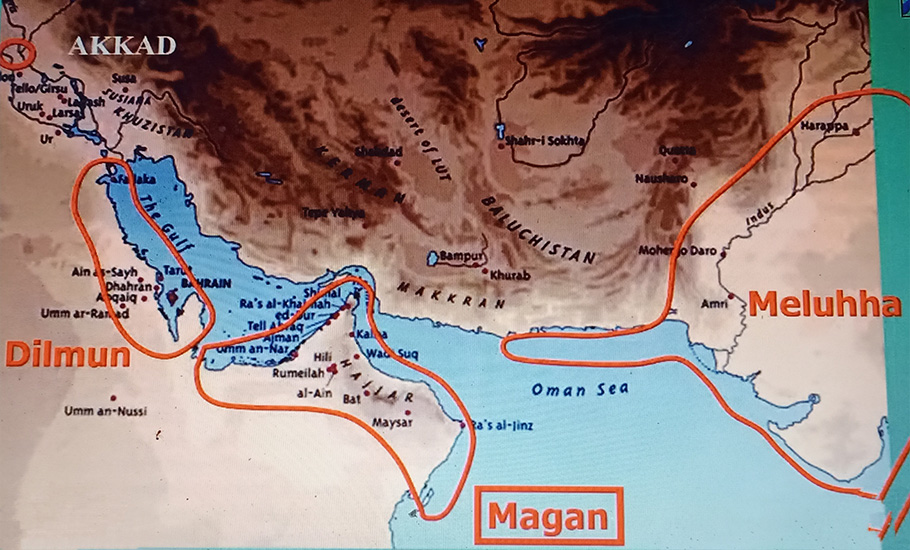
Meluhha, which is identified with the Indus Valley Civilisation, has been mentioned 76 times in the Mesopotamian texts and it shows IVC’s trade and commercial connections with Akkad (capital of Mesopotamia), Dilmun (eastern Arabia), Magan (today’s Oman and UAE) during the 3rd millennium BC. The texts say boats from Meluhha were anchored in Agade (Akkad) harbour dating to the mid-3rd millennium BC. Discovery of Kuntasi, a jetty in Rajkot district of Gujarat, which is believed to be active during the Harappan period, stands testimony to the fact.
Also Read | Echoes of a stamping drama from the coast of Kerala
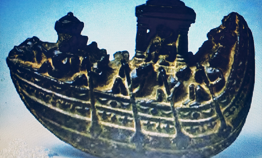
With a coastline of more than 7,500 km long, India today is dotted with several ancient port towns of different bygone eras of which many have been abandoned. These port towns, according to Gaur, were not only the centres of trade and commerce but also served as exchange of ideas which ultimately served as a vehicle for the growth of human society in different periods of history. Stone anchors, artefacts, structures and water-crafts are the most important objects that many rely on to study the history of maritime trade and commerce.
The maritime excavations in Gujarat’s Dwarka, one of the most important religious places of the Hindus, was a turning point. The town is situated on the extreme west coast of India. According to Vishnu Puran, a Hindu mythological text, Dwarka is the city of Lord Krishna, who created it by reclaiming 12 yojana land from the sea. The town consisted of beautiful gardens, deep motes, several ponds and palaces. The great epic Mahabharata says the glorious town Dwarka was submerged under the sea just after the death of Lord Krishna. The first archaeological excavation in search of Dwarka’s submerged part began in 1963. However, a series of underwater excavations conducted between 1983 and 1990 in which AS Gaur was involved revealed stone blocks, pillars and a fortified foundation. At least 120 stone anchors of various shapes and sizes were found.
Stone anchors are considered one of the important material vestiges associated with the navigation systems of the ancient and mediaeval periods. They are the basic requirement of navigation as every ship needs to be anchored in the sea during its voyage. But when Gaur and his team first saw the stone anchors, they were clueless about the use of this object.
While some anchor stones were triangular in shape with a circular hole above and two square holes below, others were in rectangular shape with a circular hole above and two rectangular holes on either face. There was one more type in a circular shape with a hole in the centre. The confusion led the team to contact a group of archaeologists abroad.
“We found at least 120 stone anchors while conducting the underwater excavations in the waters of Dwarka. The stone anchors vary in shapes and sizes. We were clueless because we had never seen this anywhere before. We then contacted a team of archaeologists who were doing underwater excavation in the Mediterranean Sea. They said the objects that we found were anchor stones. This was the largest number of stone anchors found anywhere in the world. The amount and varieties of anchors suggest that maritime contacts of Dwarka were with various countries in different phases of history,” said Gaur, while speaking on ‘Maritime Archaeology in India’, as part of the Chennai-based Tamil Heritage Trust’s Indology Festival 2023 called ‘Sagara Sangamam: India and the Sea’ held recently.
Archaeological discoveries along the Indian coast have indicated that maritime traditions are as old as its civilizations. “The Harappan people used the Gujarat coast as the most potential area for maritime activities and also the exploitation of marine resources like shells, fish and salt. Explorations at Dwarka and Bet Dwarka confirmed their important role in the history of maritime activities. An onshore exploration in Porbandar brought to light for the first time the remains of a late Harappan settlement dating back to 16th-14th Century BC, which is very similar to that from Bet Dwarka,” said Gaur, who is the author of Harappan Maritime Legacies of Gujarat.
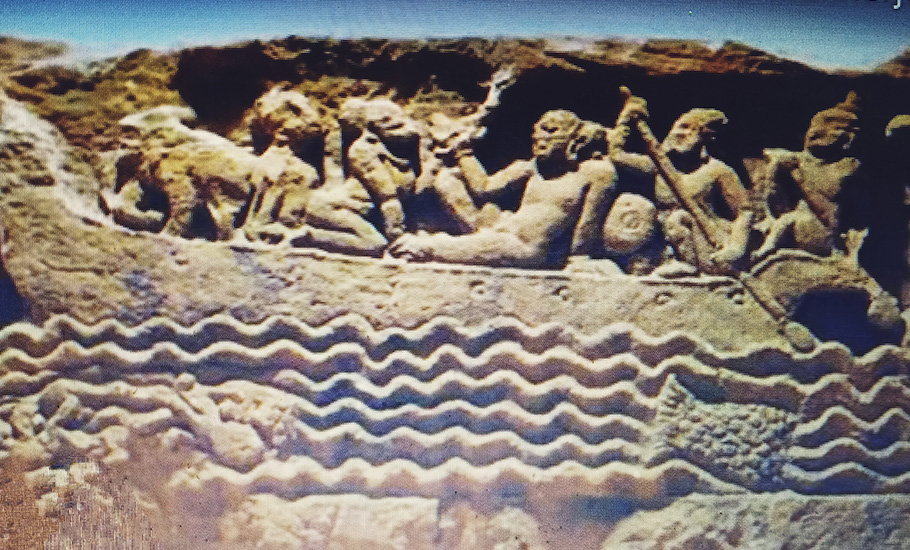
Finnish indologist Asko Parpola had an interesting observation about the movement of boats. He said, “The Harappan ships probably followed the coastline during daytime; in case they accidentally lost the way and came to open sea, they seem to have kept in their ships birds, which on being released flew towards land and thus showed the way.”
Before the introduction of metal anchors, wooden and composite anchors made of wood and stones were used in many parts of the world. Stone anchors are the relatively well-preserved material remains of the watercrafts, which were made of perishable wooden material, according to V Selvakumar, a faculty member in the Department of Maritime History and Marine Archaeology, Tamil University, Thanjavur.
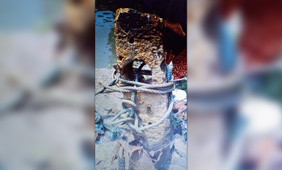
“Broken and lost stone anchors are found in abandoned and reused conditions in many coastal and intertidal zones of India and such stone anchors have been documented and studied. Some of these anchors – labelled as Indo-Arabian or grapnel type – are composite in nature, where a carved stone block constitutes the shank, and the flukes were made of wood. In 2018, we identified an Indo-Arabian type anchor which was used by people near a boatyard as a bollard to secure contemporary boats and barges near Beypore in Kerala,” he said.
The weight of the stone is estimated to be around 438 kg and perhaps the boat was around 250 to 300 tonnage. “It is not certain when and how the anchor was abandoned. The source of the limestone used in the anchor is not clear. Since no datable material is found in association, the anchor can be safely dated to the Late Medieval period, between 15th and 18th Century CE, based on the written accounts. Since Beypore was an active port and ship building yard mainly for the Uru type of boats, the find of stone anchor is very much in tune with the maritime connections of India with the West Asian region,” said Selvakumar. Beypore is an important maritime centre of navigation and ship-building in the history of Kerala as well as the Indian Ocean from the mediaeval period.
Scholars believe that Lothal on the head of Gulf of Khambhat was an international trade centre during the Harappan period. Gaur said there are several references in Mesopotamian inscription about the trade and commerce with the IVC. What did the Mesopotamians import? Semi-precious stone, shell artefacts and teak-wood. Why? During the historical period, several ports along the Indian coast – such as Dwarka, Somnath, Bharuch, Sopara, Elephanta, Goa, Malpe, Muziris on the west coast and Korkai, Poompuhar, Vasavasamudram, Arikadedu, Machilipatanam, Palur and Tamralipti on the east coast – were active.
“The early mediaeval period saw the Arabs dominating power in the Indian ocean and they traded for nearly 1,000 years. Their trade activities were spread from China, Malaysia, and Indonesia on the east and Mombasa, east African coast and Red Sea on the west. Indian spices, semi-precious stones and teak-wood have always been the attraction for the foreign navigator to venture to the Indian coast,” he added.
When we talk about ancient maritime trade, we should also think of the facilities available those days. There was no mechanised boat and GPS unlike today. Despite all those shortcomings, a vibrant maritime trade existed, particularly through the Indian Ocean. How? The predictability of a homeward wind made the Indian Ocean the most benign environment in the world for long-range voyaging, said Himanshu Prabha Ray, professor, Munich Graduate School of Ancient Studies and Member, Oxford Centre for Hindu Studies, Oxford. She said it was the monsoon winds that made maritime mobility possible. Dhows or traditional sailing vessels of the Indian Ocean utilised the south-west monsoon only during its build-up and decline.
