
- Home
- India
- World
- Premium
- THE FEDERAL SPECIAL
- Analysis
- States
- Perspective
- Videos
- Sports
- Education
- Entertainment
- Elections
- Features
- Health
- Business
- Series
- In memoriam: Sheikh Mujibur Rahman
- Bishnoi's Men
- NEET TANGLE
- Economy Series
- Earth Day
- Kashmir’s Frozen Turbulence
- India@75
- The legend of Ramjanmabhoomi
- Liberalisation@30
- How to tame a dragon
- Celebrating biodiversity
- Farm Matters
- 50 days of solitude
- Bringing Migrants Home
- Budget 2020
- Jharkhand Votes
- The Federal Investigates
- The Federal Impact
- Vanishing Sand
- Gandhi @ 150
- Andhra Today
- Field report
- Operation Gulmarg
- Pandemic @1 Mn in India
- The Federal Year-End
- The Zero Year
- Science
- Brand studio
- Newsletter
- Elections 2024
- Events
How the failure of a satellite’s atomic clock has put India’s national security at risk
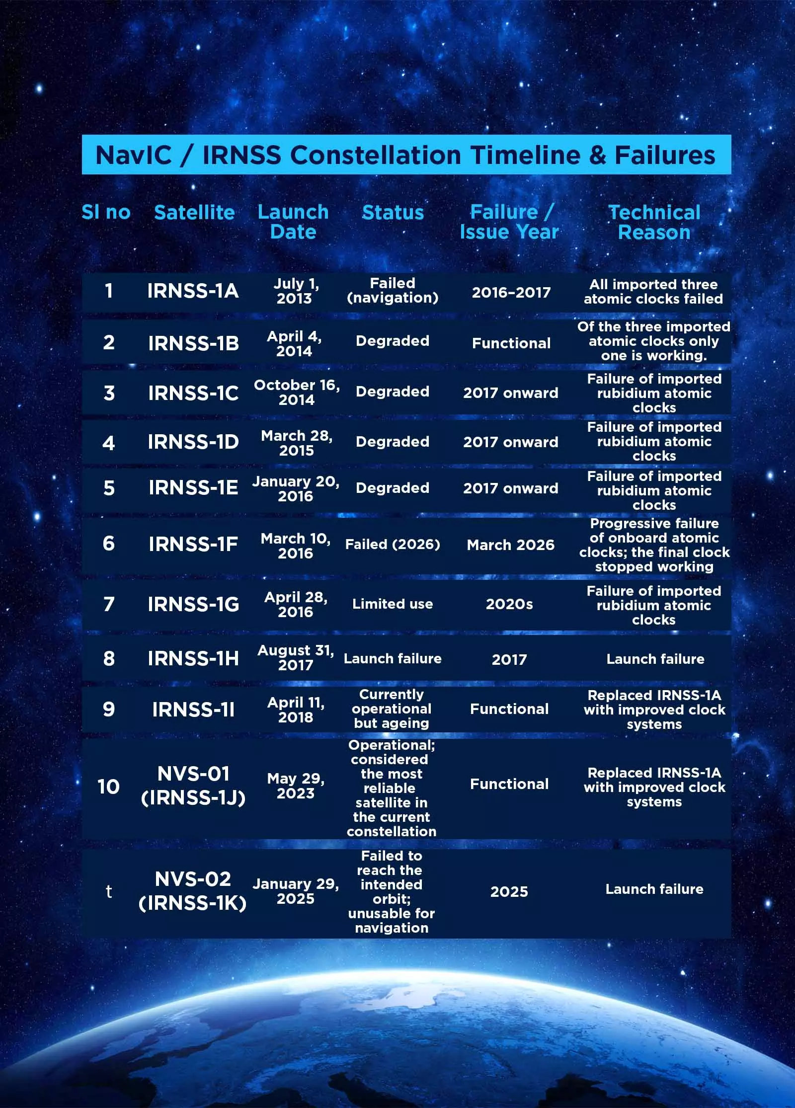
Failure of atomic clock on IRNSS-1F satellite has crippled India's autonomous navigation capability. An atomic clock ticks at the heart of a navigation satellite. Even a tiny error in time could impact location accuracy. A minimum of four satellites is needed to provide navigation capabilities. However, of the 11 satellites launched for the Indian system since 2013, only 3 are functional.

The atomic clock on the IRNSS-1F satellite failed on March 13. That was the last nail in the coffin of NavIC (Navigation with Indian Constellation), India's homegrown 'GPS', earlier known as the IRNSS (Indian Regional Navigation Satellite System). With the loss of this satellite, India's autonomous navigation capability is crippled.A minimum of four satellites is needed to provide...
The atomic clock on the IRNSS-1F satellite failed on March 13. That was the last nail in the coffin of NavIC (Navigation with Indian Constellation), India's homegrown 'GPS', earlier known as the IRNSS (Indian Regional Navigation Satellite System). With the loss of this satellite, India's autonomous navigation capability is crippled.
A minimum of four satellites is needed to provide navigation capabilities using this constellation. However, out of the 11 satellites launched since 2013, only three, IRNSS-1B, launched in April 2014, IRNSS-1L, launched in April 2018, and NVS-01, the first of the second-generation NavIC satellites, launched in May 2023, are functional.
How does the satellite-based navigational system work?
Navigation satellites are like modern-day lighthouses. Instead of sending a beam of light, these satellites continuously broadcast a pulse of signals with timestamps and their locations. The phone or GPS receiver catches these signals and measures how long each one took to arrive. Because radio waves travel at the speed of light, even a tiny difference in travel time can be turned into a distance. For example, if a signal took slightly longer to reach you, the receiver knows that the satellite must be farther away.
With distance from at least three satellites, your receiver performs a process called triangulation. Triangulation is like finding your location by asking three friends how far you are from them. Each distance forms a circle around a friend. Where all three circles meet is your exact position. That intersection is your exact position, latitude, longitude, and altitude. Navigational satellites do the same by measuring signal travel time rather than using a measuring tape.
Also read: Beyond bombs and bunkers, how Iran has cemented its place in the world of science and technology
Theoretically, for triangulating the position, signals from three satellites are adequate. But the fourth is essential to correct the receiver's own clock error, because your phone's clock is not as precise as the atomic clocks on the satellites.
With only three functioning, the NavIC system is practically limping; it’s providing position service with much reduced accuracy, inadequate for security and other operations.
During the middle of the Kargil war, during a crucial phase, the US allegedly refused to share GPS data and deliberately manipulated and disrupted, causing an immense hurdle to the Indian defence forces. Likewise, during a crucial missile test, the precision GPS services were reportedly terminated, disrupting the test. These experiences led India to consider developing its own regional navigational and positioning system. ISRO took up the challenge and developed the IRNSS project.
While four is the bare minimum for 24/7 service, one may need more satellites in the constellation. ISRO decided to launch seven satellites to provide regional service. Alas, it had to rely on a foreign supplier for the crucial atomic clocks.
Currently, there are four Global Satellite Navigation Systems (GNSS). The GPS from the USA provides service with more than 30 satellites. GLONASS from Russia consists of 24+ active satellites, providing global coverage and 2.8–7.38-meter accuracy. With a constellation of over 30 satellites, the European Union's (EU) Galileo system can provide precision down to the decimeter level. China’s BeiDou global network requires a fleet of 30 satellites; around 35 are currently in orbit. In addition to Indian NavIC, Japan's QZSS is also a regional satellite-based navigation system.
An atomic clock ticks at the heart of a navigation satellite. Time is measured not by seconds ticking away, but by the natural vibrations of atoms. Unlike conventional quartz-based clocks, which can drift by a second in just a few days, atomic clocks are so precise that they gain or lose only one second in about 100 million years.
A signal travels from the sky to your phone; the clock notes how long it took. A tiny error, even a billionth of a second, would mean your location could be off by hundreds of metres. No working clock, no navigation. That is why satellites often carry more than one. ISRO put three clocks on each. Redundancy, they call it. If one fails, the others take over. The system keeps running.
While ISRO could build and launch satellites, the crucial atomic clock was a challenge. To speed up the launch of the regional-level navigational positioning system, India decided to import the atomic clocks.
Also read: Why ISRO’s handling of post-failure transparency after PSLV-C62 mission loss will be closely watched
The first NavIC satellites carried Swiss rubidium clocks. Supplied by SpectraTime.
Then the troubles began. IRNSS-1A, 1C, 1D, 1E, 1G, and eventually 1F, clocks failed prematurely. In five of these satellites, all three clocks stopped working. In the others, one or two failed, shortening the satellite's useful life.
It was not just India facing this. European satellites had similar failures. The European Space Agency investigated the cause of the failures in 2017. Short circuits, possibly during ground testing, were blamed. For any navigation system, a failed clock means a failed satellite. Precise timing is everything.
China took a different path. They used various imported clocks and soon developed their own. Imports stopped.
The writing on the wall was clear; if India had to build and operate its navigational system, it had to develop its own atomic clocks. Work on an indigenous rubidium clock began in the mid-2010s. By 2022–23, the Indian Rubidium Atomic Frequency Standard was fully qualified. Today, the new NVS-series satellites carry these home-grown clocks.

File photo of integration of IRNSS-1F satellite. Courtesy: isro.gov.in
Making a satellite, especially a navigation satellite, requires the involvement of technical personnel. Budget is also imperative. With a growing portfolio, deep-space projects, missions to the Moon and Mars, planned human space missions, the launch of commercial satellites, and the development of new-generation launch vehicles, ISRO is stretched. Reliable sources say that while the workload has expanded, there has been no commensurate increase in the number of technical personnel. The budget is also insufficient. The construction of the new series of navigational satellites is not at a phase one would desire.
An Indian satellite-based positional and navigational system is not a luxury but a necessity in the emerging international scenario. Recent global events show that without self-reliance, India could get itself into a spot. The drive for 'self-reliance' may not be anachronistic; perhaps it has become the need of the hour.