
Who is encroaching on Chennai lakes? Government buildings, say experts

Mercury witnessed a dip in Chennai in the last few days, thanks to the mild showers. However, millions in the city were witness to another major slump — the satellite images of extremely shrunk lakes, the core water source for the parched city.
The images showed the extent to which the lakes had dried up across the city this summer. While this drew shocking reactions from across the spectrum, what is more appalling is the extent to which the water bodies have lost out space due to encroachment. And according to experts, it is the government bodies that have taken up most of the space.
Satellite images sourced by an independent researcher, show that the bodies of governments — Centre, state and local — in the present and past have encroached on the water spaces.
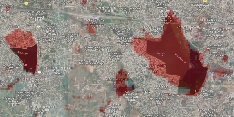
Researcher Raj Bhagat Palanichamy, who tracked trends of peripheral water bodies situated in important regions like Ambattur, Kolathur, Velachery, Villivakkam and Pallikaranai between 1973 and 2019, said that the encroachments made by various government bodies is one of the major reasons for the loss of water sources in the city.
Karen Coelho of the Madras Institute of Development Studies had in the Caravan magazine in 2016 written: “In the 1970s and 1980s, the Tamil Nadu Housing Board (TNHB) and the Chennai Metropolitan Development Authority created schemes to fill in ‘defunct’ eris (lakes) to create land for housing, markets, and bus stands. In Ambattur and Mogappair, TNHB housing colonies for middle and high income groups (MIG and HIG) were built on lake-beds, as part of World Bank-funded ‘Eri Schemes’. Not surprisingly, TNHB colonies were among the worst-affected housing developments in the recent floods, even in places like Avadi that otherwise remained relatively safe”.
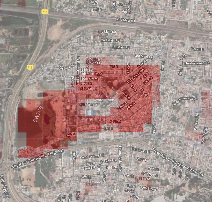
Similarly, the Villivakkam lake, which was once a natural drain, has been battered by dumping of debris. It is said that the lake in 1972 had a size of 214 acres which has now shrunk to just 20 acres, in part, because much of it has been eaten up by the SIDCO Industrial Estate and SIDCO Nagar housing.
In addition to this, it has been reported that the Chennai Metropolitan Water Supply and Sewerage Board has allotted a part of the lake to Chennai Metro Rail.
In its report titled ‘Audit of Chennai Waterways – A Citizen’s Effort’, the Arappor Iyakkam and Magasool Trust has said that the “Metro Rail has been dumping its sand into the lake” which led to the further shrinking of the lake.
Pallikaranai marshland, which is called the ‘flood sink area’ of the city, is witnessing continuous efforts to destabilise its flood water absorbing capacity. The marshland by one account had more than 5,000 hectares in the 70s. It is now less than 600 hectares.
Activists say that the marshland is being considered by the state as a ‘wasteland’ and many development projects are being carried out with the government’s approval.
In the recent past, a good part of the area has been allotted to the Mass Rapid Transit System, the National Institute of Ocean Technology and the Centre for Wind Energy Technology.
Pallikaranai wetlands has been facing destruction from all corners. All forms of urbanization have been experimented over the wetlands and currently there is a landfill, a railway shed, road, houses and multiple institutions over the wetland.
The Velachery and Kolathur lakes have similar tales to tell due to giving away to TNHB housing projects and the MRTS.
The Velachery lake shown in the image has lost 81 per cent of its original surface area. Old satellite images from 1973 shows the real extent of the old lake.
Now, despite the rains, the city’s groundwater levels are unlikely to rise much, according to experts.
“Unscientific approaches in dealing with our water bodies is affecting the city’s livability conditions now,” Palanichamy said.
