Explained: What is land subsidence, reason why Joshimath is sinking

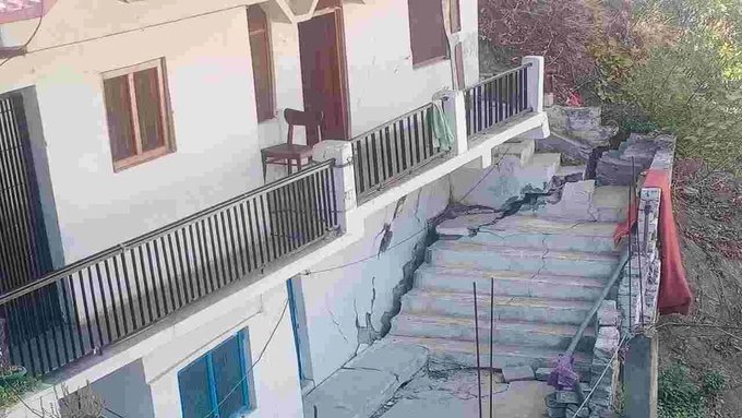
Three days ago, on Sunday, authorities declared Joshimath in Uttarakhand a land subsidence and landslide-hit zone. The decision came a week after cracks appeared in many buildings and roads in the city that serves as an overnight stop for people visiting important religious and tourist locations in the state like Badrinath, Auli, Valley of Flowers and Hemkund Sahib.
The declaration came after a high-level meeting between senior Central government officials, Uttarakhand state officials and top officers from agencies like the National Disaster Management Authority (NDMA), Geological Survey of India (GSI) and the National Institute of Hydrology (NIH).
Also read: Joshimath declared landslide-subsidence zone, over 60 families evacuated: Official
What is land subsidence?
According to the United States Geological Survey (USGS), land subsidence is a gradual settling or sudden sinking of the Earth’s surface due to the removal or displacement of sub-surface earth materials. The National Oceanic and Atmospheric Administration (NOAA) explains it as sinking of the ground because of underground material movement.
The principal causes include aquifer-system compaction associated with groundwater withdrawals, drainage of organic soils and underground mining. Subsidence can also be caused by natural events such as earthquakes, soil compaction, glacial isostatic adjustment, erosion, sinkhole formation, and adding water to fine soils deposited by wind.
As NOAA puts it, “Subsidence can happen over very large areas like whole states or provinces, or very small areas like the corner of your yard.” Also, where groundwater depletion is involved, subsidence is typically gradual and widespread, as is the case in Joshimath.
A landslide is defined as the movement of a mass of rock, debris, or earth down a slope. It is a type of mass wasting, which denotes any downward movement of soil and rock under the direct influence of gravity.
The case of Joshimath
According to the Uttarakhand State Disaster Management Authority (USDMA), Joshimath falls in Zone V of the Seismic Zonation Map and has witnessed several earthquakes of magnitude of less than 5 on the Richter scale.
Scattered rocks in the area are covered with old landslide debris comprising boulders, gneissic rocks, and loose soil with a low bearing capacity. The gneissic rocks are highly weathered and have a low cohesive value with a tendency of high pore pressure when saturated with water, especially during monsoons.
Also read: Joshimath sinking: SC declines urgent hearing; demolition to begin today
Widespread floods in June 2013 in Uttarakhand and flooding of Rishi Ganga in February 2021 had adverse impact on the landslide zone as a result of extreme erosion. According to the latest satellite data, mountain streams have expanded their channels and changed course, thereby inducing more slope instability in an already fragile belt.
Further, Joshimath being on a fault line — where the Indian plate pushes under the Eurasian plate along the Himalayas — makes it highly vulnerable to sinking because of tectonic activity.
According to the 1976 M C Mishra Committee report, Joshimath is situated over a deposit of sand and stone, which is not the main rock. The report pointed out that the town lay over an ancient landslide and hence was not suitable for a township. It also added that undercutting by currents of Alaknanda and Dhauliganga rivers also played a part in triggering landslides.
The report warned against the removal and blasting of boulders along the hillside, recommended restrictions on major construction activities and said that water seepage from the soil should be properly removed through drainage channels to avoid landslides.
The reasons for Joshimath’s sinking
Apart from the above geological and geographical reasons, unplanned construction, over-population, obstruction of the natural flow of water, hydel power activities and the widening of the National Highway are also being cited behind land subsidence in Joshimath. Also, lack of a proper drainage system might could have also contributed to the sinking of the area.
As per media reports, residents have also blamed NTPC’s Tapovan Vishnugad Hydro Power Project for the incident. They allege that the tunnel had water seepage “from a punctured aquifer, leading to the drying of water sources in Joshimath.” Experts suggest that it could be one of the reasons for the collapse of the area.
However, NTPC denied the allegations and, in a statement, said, “The tunnel built by NTPC does not pass under Joshimath town. This tunnel is dug by a tunnel boring machine (TBM) and no blasting is being carried out presently”, according to a report by The Indian Express.
The same report also pointed out that a tunnel boring machine (TBM) was employed for excavating the tunnel for the project and, in 2009, it punctured water-bearing strata. Experts had then “warned that this sudden and large-scale de-watering of the strata had the potential of initiating ground subsidence in the region,” the report added.
Widening area
To make matters worse, fresh cracks have also appeared in houses at Karanprayag, another holy town 80 km downstream of Joshimath. Here too residents blame heavy construction by NTPC for land subsidence. However, the NTPC denied any link between its construction activities and cracks in Uttarakhand towns.
Also watch: After Joshimath, fresh cracks reported from houses in Karnaprayag
Construction work on the Tapovan Vishnugad project has been stopped until further orders, as also work on widening the all-weather Char Dham road between Helang and Marwari and the Joshimath-Auli ropeway.

