







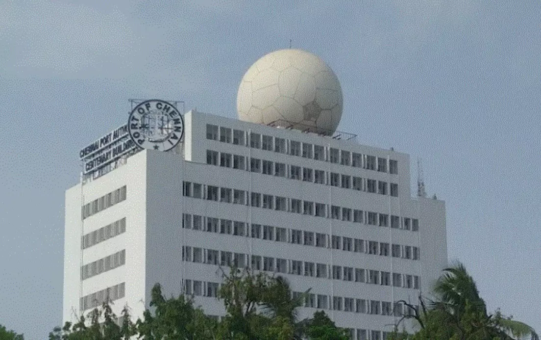
The giant football-shaped S-band Doppler Weather Radar on the Chennai Port Trust Centenary Building is under maintenance.
Exclusive: Iran war delays Chennai’s new cyclone radar as S-band DWR down
The German-made S-band Doppler Weather Radar at Chennai Port has monitored the Bay since February 2002, when it became India’s first Doppler weather radar. The new S-band, ordered to replace it, will not be installed before July 2027

A Deep Depression is crossing the north Andhra Pradesh-south Odisha coast tonight (September 23). Chennai’s own long-range cyclone radar is not fully on the job. That is the operational fact behind a larger science story: a 24-year-old German S-band Doppler Weather Radar (DWR) on the Chennai Port Trust Centenary Building is under maintenance just as Tamil Nadu enters its most radar-dependent weeks of the year.
The India Meteorological Department’s (IMD) Regional Meteorological Centre (RMC) told The Federal that the old set is in trial mode and should return in about a week. The new S-band, ordered to replace it, will not be installed before July 2027. The supplier’s explanation, conveyed by RMC, is that one spare must come from the United States, and Iran war-related disruption has delayed it.
India’s first Doppler weather radar
Therefore, a coastal megacity is watching a Bay system with a patchwork of shorter-range and neighbouring radars, not with the instrument built for this coast.
The German-made S-band Doppler Weather Radar at Chennai Port has monitored the Bay since February 2002, when it became India’s first Doppler weather radar. Mounted on the Port Trust Centenary Building, 53 metres above the sea and sheathed in an 18-tonne spherical radome, it can scan a 500 km radius for cyclones, rain-bands, wind speed and direction, the long-range eye the city is missing this week. X-band radars see finer rain detail, but operate over a shorter range, typically 100-150 km and they attenuate faster in intense cells.
Also read: Breakfast battle: Vijay vs Stalin war of words over free school meal scheme expansion
Chennai has both. The X-band at the National Institute of Ocean Technology (NIOT), Pallikaranai, is the city’s nowcast workhorse. The Port S-band is the cyclone tracker. When the S-band is sick, forecasters can still issue warnings. They cannot see the same storm the same way.
IMD’s live network and recent reports have listed the Port unit as under slew-ring/maintenance work. Independent weatherman K Rajesh cautioned about the operational consequence: if the Doppler is down, long-lead rain nowcasts suffer. Radar tracks cloud motion; it does not invent a cyclone by itself. “In a cyclone period, if the Doppler is not working, it is difficult,” he said. Local radar, he added, can track clouds over about 400 sq. km. For the large November-December systems, and even to flag pre-monsoon cells early, the S-band is not optional.
Doppler under maintenance
Dr. Sivananda Damodara Pai, Scientist-G and Head of Office, RMC Chennai, confirmed to The Federal that the present Doppler is under maintenance. He drew a line between the two machines. The old radar, he said, is an ageing unit. Regular maintenance is under way. “We will do it within a week. It is an old radar issue. Before the cyclone season we will repair it. It is now running in trial mode. It will be back in service soon.” Until then, he said, the NIOT radar is adequate for local prediction. S-band, in his words, is essential in the cyclone season. Visakhapatnam and Machilipatnam radars are also in operation. “Before the cyclone, everything will be right.”
The replacement is a different calendar. RMC has placed an order for a new radar. The vendor has not supplied on time. The S-band company, Pai said, told IMD that one spare must come from the US and that its arrival has been hit by the Iran war. Installation, first aimed at July this year, is now planned for July next year.
That is the supply-chain sentence the city will remember. It should be read as the manufacturer’s explanation, relayed by the Head of RMC, not as a customs docket proving a single missile delayed a bearing. Global radar parts are bespoke. The 2002 German set has already taught Chennai that lesson. After a bull-gear failure, spares were scarce, COVID stretched the wait, and ISRO’s ISTRAC plus local engineering shops rebuilt a unit in 2022 to keep the old radar alive. Parliament replies in 2022 said the same thing in official language: twenty-year-old S-band spares are not on the open market.
Deep Depression to cross between Visakhapatnam and Gopalpur
Meanwhile, as of Wednesday morning, IMD placed the Deep Depression location about 60-70 km from Kalingapatnam, 140-150 km from Visakhapatnam, Andhra Pradesh, 150 km south of Gopalpur, Odisha. It is expected to cross between Visakhapatnam and Gopalpur, close to Kalingapatnam, Andhra Pradesh, as a Deep Depression by night. Winds are in the 55-65 kmph range, gusting to 75 kmph just below the cyclone threshold. RMC Chennai has forecast light to moderate rain with thunder for Chennai and neighbouring north Tamil Nadu districts, not a direct landfall on the city.
Also read: Ambika slams sister Radha’s cheque-fraud charge: 'I should be the one suing'
Fortunately, the system now over the sea is not crossing the Tamil Nadu coast, says Rajesh; had it made landfall here, tracking its path with accuracy would have been far harder without the Doppler radar.
That is precisely when a working local S-band earns its keep: not only for the landfall point, but for outer rain-bands, squalls off the Tamil Nadu coast, and the two-to-three-hour nowcast that decides whether a neighbourhood floods.
‘Chennai left blinded just before Northeast Monsoon’: MP Maran
Dayanidhi Maran, DMK MP from Chennai Central and Deputy Leader of the party in the Lok Sabha, told The Federal the city is “left blinded just before the Northeast Monsoon”. He has written to Prime Minister Narendra Modi on 2 December 2020 and 12 November 2021, and asked questions in Parliament on 8 December 2021, 16 March 2022, 20 July 2022 and 7 August 2024. The Union government’s reply, he said, was that the radar had been handed to ISRO and that work was under way.
“Weather monitoring cannot be treated as an afterthought for a coastal metropolitan city like Chennai,” Maran said. He pointed to the State’s 2022 push for extra radars, automatic weather stations and rain gauges, and argued that when a critical radar stays unavailable, redundancy must exist so that disaster preparedness is not compromised.
Also read: ‘Super El Nino’ could put over 450,000 lives at risk from extreme heat
During his 2022 Budget speech, then Finance Minister Palanivel Thiaga Rajan allocated Rs 10 crore for an advanced early-warning system within state's ambiguity: supercomputers, weather balloons, two radars, 100 automatic weather stations, 400 automatic rain gauges and 11 water-level sensors. The political phrasing at the time was a State system that would cover gaps when the Port radar was down. On the ground, that package did not become a Tamil Nadu weather office. Official forecasts still come from IMD. The State later shifted towards two Tamil Nadu Disaster Risk Reduction Agency (TNDRRA) radars, planned at Yercaud and Ramanathapuram plus extra sensors, and the Centre listed three more sites under Mission Mausam at Kanniyakumari, Tiruchi and Coimbatore.
Sundarrajan of environmental organisation Poovulagin Nanbargal said the 2022 centre “has not come into operation till today” and should be revived. He was also honest about time: start now, and a reasonably precise State capability takes five to 10 years, along with the drainage works that actually stop a flood.
What experts said
Samuel Selvaraj, Head of Physics and Associate Professor at L.N. Government College, Ponneri, said a Tamil Nadu-specific weather model is feasible. The method is downscaling: take Global Forecast System data and nest a finer model over the State. IMD now warns by district or meteorological subdivision. Downscaling, he said, could split Chennai into four parts and estimate rainfall and storm behaviour by pocket. He has published work on the method. “If the State brings experts together, it is possible.”
Also read: Gem Veeramani POCSO case explodes into TVK-DMK bypoll battle
Independent forecaster Pradeep John made the same point in kilometres. Current public guidance often sits at a 12-22 km grid. Downscaling can go below a 12 km grid, making it small enough to treat Chennai as several weather zones rather than one colour on a map. Give researchers a State centre, he said, and cyclone and rain forecasts can move to the next stage.
None of that replaces an S-band during a cyclone. Models need observations. Radars, AWS units and rain gauges are the observations. A downscaled model fed by a thin network will still miss a cell that trains over Ambattur while Adyar stays dry.
