Lower pressure in Bay of Bengal to intensify into cyclone next week

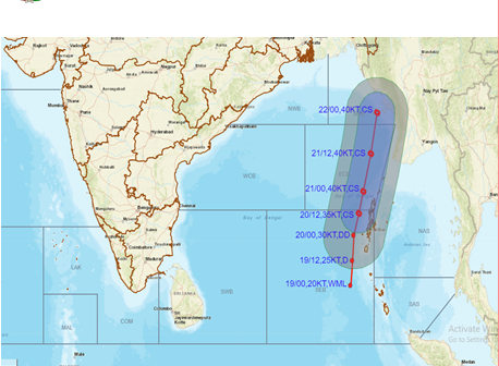
A low pressure area brewing over southwest Indian Ocean is expected to intensify into a cyclone by early next week with forecasts suggesting that it may move towards Bangladesh and adjoining north Myanmar, the weather office said on Wednesday (March 16).
The low pressure area (LPA), which was formed on Tuesday, was expected to move east-northeastwards and become a well marked LPA by Saturday and subsequently move along and off Andaman & Nicobar islands before intensifying into a depression, the India Meteorological Department said.
The weather system was expected to further intensify into a cyclonic storm on March 21 and continue to move north-northwestwards till March 22.
Once the system intensifies into a cyclone, it will be named Asani, which is a name suggested by Sri Lanka.
“Thereafter, it will move north-northeastwards and reach Bangladesh and adjoining north Myanmar coast by morning of March 23,” the weather office said.
Sea condition is very likely to become rough over southeast Bay of Bengal and adjoining south Andaman Sea on Thursday and Friday.
The weather office has advised fishermen not to venture into central parts of south Bay of Bengal and adjoining Equatorial Indian Ocean on Wednesday and into southeast Bay of Bengal and Andaman Sea area on Thursday and Friday.
It has also advised fishermen not to venture into Andaman Sea and along and off Andaman and Nicobar Islands during between Saturday and Tuesday.
Andaman and Nicobar Islands are expected to experience squally winds on Sunday which were likely to intensify to gale winds with speeds reaching 70-80 km per hour, gusting to 90 kmph the next day.
(With inputs from agencies)

