Sharp fall in Tamil Nadu’s mangrove cover, reveals forest survey report
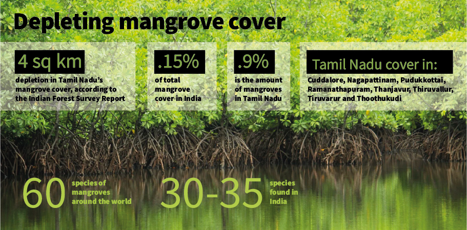
Tamil Nadu’s mangrove cover has depleted by 4 sq km in the last two years. According to the Indian Forest Survey Report, released on Monday, it has come down to 45 sq km in 2019 from 49 sq km in 2017.

Tamil Nadu’s mangrove cover has depleted by 4 sq km in the last two years. According to the Indian Forest Survey Report, released on Monday (December 30), it has come down to 45 sq km in 2019 from 49 sq km in 2017.
Having 13 coastal districts, the sharp fall is of serious concern, since the vegetation acts as a natural wall, providing security from adverse weather conditions.
Besides playing a crucial role in controlling high tide, the importance of mangroves was proven during the 2004 Tsunami. This vegetation accumulates sediments, quells sea waves and stalls coastal erosion. It also acts as an ecosystem which supports, marine life and pelagic bird species.
India accounts for 0.15% of total mangrove cover in the world, with Tamil Nadu holding 0.9% of it. Across the world, mangroves estimates for 15 million ha, which is just 1% of the total forest cover in the planet. South Asia, with 6.8% mangrove cover has the largest distribution in the world.
“The loss of mangrove cover in Tamil Nadu can be attributed to the Cyclone Gaja, which ripped the state in 2018. In Muthupettai, Tiruvarur district alone around 70 to 80% of mangroves were destroyed. That could have been reflected in the report,” says V Selvam, a Chennai-based environmental scientist.
While states like Gujarat, Maharashtra and Odisha have seen an increase in cover, Tamil Nadu and West Bengal have seen a decrease in the cover by 4 sq km and 2 sq km, respectively. The status of mangrove cover in other coastal states like Andhra Pradesh, Karnataka, Kerala and Union territories like Goa, Daman and Diu and Puducherry are intact. Andaman and Nicobar islands have seen a fall in mangrove cover by 1 sq km.
In Tamil Nadu, the mangroves are distributed in eight districts namely Cuddalore, Nagapattinam, Pudukkottai, Ramanathapuram, Thanjavur, Thiruvallur, Tiruvarur and Thoothukudi. Except in Ramanathapuram and Thanjavur, the mangrove cover has decreased in all other districts.
There are close to 60 species of mangroves, worldwide, of which India has 30 to 35 species. Though mangroves are salinity tolerant, most of the species can grow in the salinity range between 10 to 20%, says Selvam.

Mangroves are also the backbone for the livelihood of tribal communities like Irulas in Tamil Nadu, as they fish in these backwaters. Various species of fish use their roots to lay eggs due to their high nutrient content.
“Mangroves can attain maximum growth only in low salinity conditions. In higher salinity, the photosynthetic capacity of mangroves reduces and it affects its growth. In order to control salinity, freshwater should flow regularly. The reproduction of mangroves takes place only in freshwater. Between October and December, in the rainy season, mangroves get freshwater. But due to climate change, the rainfall becomes erratic. Also, a number of dams constructed in Cauvery after 1924, diverts fresh water for irrigation. Because of these reasons, the freshwater flow has now decreased,” said Selvam.
Also read: 2,141 trees cut in Aarey colony; SC’s halt order brings little relief
However, in recent times, land sharks have also destroying mangroves for developmental activities. Taking advantage of this there has also been a surge in mangroves being cut to be used as firewood.
“Though the increase and decrease of the mangroves can be a natural phenomenon, recently, human activities have become a major factor for their depletion. Organisations like MS Swaminathan Research Foundation (MSSRF) has taken initiatives like ‘Fishbone model of irrigation,’ which is one of the most successful methods to restore mangroves,” says A Saleem Khan, a post-doctoral researcher at Indo-German Centre for Sustainability, IIT-Madras.
A forest official told The Federal on condition of anonymity refuted the study saying, “The survey team uses satellite images and they do little fieldwork. That is not enough to assess mangrove cover. They should also know our comments before publishing the reports and we could have given the reply. But they did not ask our comments. However, we continuously do mangrove planting.”

