Why floods wrecked Tirupati? Planners, ecologists dig deep to find causes

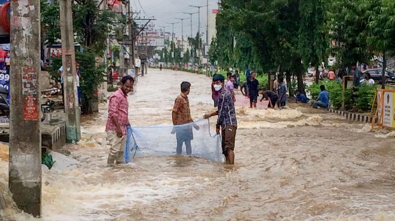
Tirupati, home to the Sri Venkateswara Temple, in Andhra Pradesh, is gradually but painfully limping back to normalcy after being severely affected by torrential rains and resultant floods in November. But, the disaster has left urban planners and ecologists pondering over the causes.

Experts say the recent flash floods witnessed in Tirupati due to intense rains over the past few days are mostly manmade. They say the disaster has exposed how human greed to build houses and the government’s failure in city planning have led to the disappearance of historical ponds dating back to the reign of Vijayanagara emperor Sri Krishnadevaraya into townships. The pitiable condition of the city’s drainage system has only aggravated the situation during rains. Ironically, Tirupati has been named a smart city and is considered the fourth largest growing city in the country.
Also read: Massive evacuation in AP as heavy rain causes crack in state’s biggest reservoir
The city with around five lakh population is located at the foot of the Seshachalam Hill ranges, the seventh peak of which houses the Balaji or Sri Venkateswara Temple. The temple nestled amid sacred waterfalls and tanks is a fine example of Dravidian art and craftsmanship and is counted among the prominent pilgrimage centres in India.
Ecologists and urban planners have accused the Tirupati Urban Development Authority (TUDA) of failing in its objective of overseeing urban growth in a healthy manner by allowing real estate to mushroom. The TUDA’s jurisdiction stretches up to Srikalahasti, Puttur and 69 surrounding villages on the east, Pileru on the west, and Putalapattu on the south with an area of 467.77 sq miles.
Mindless urbanization clogs water pathways, shrinks tanks
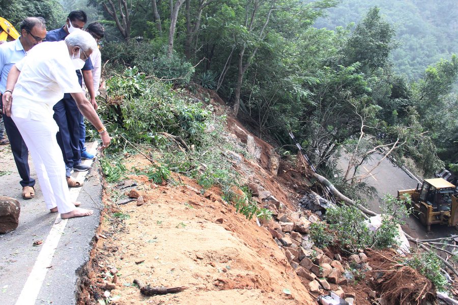
While 44 people have died due to rain-induced floods in the state, Tirupati has taken a major hit, mostly due to flooding of the hill town of Tirumala and the escape of the water to the plains. In Tirumala, the four ‘maada streets’ circling the main temple remained flooded, so did the Vaikuntham Queue Complex (cellar). ‘Darshan’ of the deity was virtually stalled due to the inundation. The Japali Anjaneya Swamy Temple on Tirumala was also inundated and idol of the deity was submerged. That apart, both the ghat roads on the Tirumala-Tirupati stretch were shut down after landslips were reported at 23 locations and uprooting of trees at 15 spots. A pillar and a portion of the four-pillar mandapam at the Pushakrinini (pond) of the ancient Sri Kapileswara Swamy Temple collapsed. According to a bulletin issued by the India Meteorological Department, Tirumala received the highest rainfall of 19 cm in a single day on November 19, a rare occurrence, leading to the discharge of rainwater down the hills.

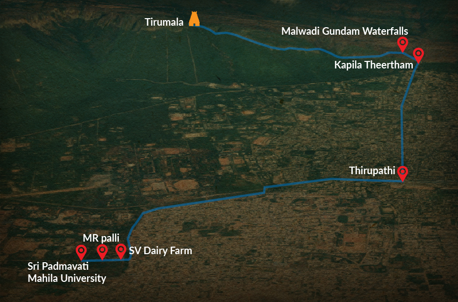
This rainwater from the hills come gushing down, hitting Tirupati through a couple of inlet channels – the one on the northeast originates at Malavanigudu or Malavanigundam (the place is believed to have acquired the name from Malas, a sub-sect of Dalits, considered outcasts, who were only allowed only up to that point at the foot of the hill shrine and from there they returned home after the ceremonial tonsure) that runs parallel to Kapilateertham. The other channel in the southwest flows from west to east to Pedda Cheruvu lake situated just opposite Palani Talkies after feeding the Peruru pond via SV Dairy Farm, Sri Padmavati Mahila University and MR Palli.

Sadly, while both the historical water bodies (Pedda Cheruvu and Peruru) have disappeared into residential colonies, inlet channels have been narrowed down and even lost their original shape at some locations, thanks to rapid encroachments.
The sprawling Pedda Cheruvu has been encroached to give way to a cluster of government offices, including the sub-collector’s office, Tirupati Urban and Rural Tahasildar offices and a police parade ground. Tirupati Urban SP office is reportedly getting ready to move into this area very shortly. Experts say, what is most worrying is that the TUDA developed most part of the water body into housing plots and sold it away.
Besides, a 50-acre pond at Tummalagunta village close to Mahila University was converted into a cricket stadium at the behest of a local MLA.
Also read: Flash floods: Roads to Tirumala shrine shut, flight service hit, pilgrims stranded
An inlet channel flowing from the north towards the eastern side, via the heart of the city, too has been clogged by encroachments.
PV Ravi Kumar, a local journalist told The Federal, “The channel has a width of 60 ft at its origin, but as it meanders through KT Road, Bramhamgari temple and Akkarampalli, the width shrinks to a mere 10-15 ft.” Ravi says this is the main reason why the south-eastern part of the city was flooded after the rains.
Political jamborees in water tanks
The historical Avilala Cheruvu lake, 200 acres in area, and dating back to the reign of Sri Krishnadevaraya, is now an eyesore. The eco-system of the water body was left damaged in 1992 when the administration at the behest of then Congress government headed by N Janardhan Reddy levelled the lake’s bed, to host a plenary of the All India Congress Committee, an event graced by then prime minister PV Narasimha Rao.
Later, the Intellectual Forum, a group of local concerned citizens, moved the Supreme Court against the destruction of the tank which led to a landmark judgment on February 23, 2006 in defence of water bodies in the temple city. Regardless of the judgment, the administration allowed megastar Chiranjeevi to launch his Praja Rajyam Party on the same tank premises in 2008.
“There are as many as 44 water bodies as per the Chittoor District Gazette publication. But none of them is in existence now,” said K Srinivasa Reddy, former principal of Mahanandi Agriculture in Kurnool district and resident of the temple. Reddy had represented the Intellectual Forum in waging a spirited battle in court to save the water bodies.
He attributed the present flood-hit fate of Tirupati to the unchecked grabbing of water bodies for residential houses, real estate ventures and government offices.
Similar is the fate of another historical tank Rayala Cheruvu, located 14 km off Tirupati. As its name suggests, it was built by King Krishnadeva Rayalu.
The tank, which once sprawled over 1,500 acres, has shrunk to just 42 acres. The tank bed is filled with silt up to 40 feet, highlighting the government’s apathy in cleaning it. The tank bund was built like a gallery with huge stones but developed breaches in the latest floods. Coming under public pressure, the administration recently repaired the breach and reinforced the bund.
Choosing urban jungles over water bodies
The increase in population and the resultant demand for land to build residential and commercial edifices has led to the filling up of 16 tanks in and around Tirupati for the construction of buildings. This loss of surface water storage (in tanks) to urban development has accelerated in recent years; six tanks were filled between 1975 and 1990 and a further 10 during 1990-2004, reveals a study on ‘Urban development and the Looming Water Crisis – A case study from Tirupati, South India’ by Janardhana Raju Nandimandalami and TV Krishna Reddy, experts in geology from SV University.
Also read: Heavy rains hit Andhra hard; 17 killed and over 100 people are missing
The Rayalaseema region under which Tirupati falls is a rain shadow region. The Vizianagara emperors with a lot of foresight built several water bodies in the drought-prone region to help in the recharge of groundwater as a measure against perennial droughts. Sadly, these water bodies in the 21st century have been allowed to disappear into concrete jungles, triggering man-made disasters.

