Nepal's radio stations broadcast anti-India speeches in bordering areas
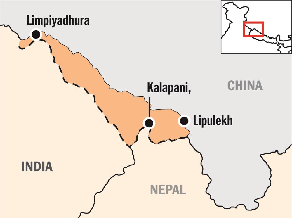
Residents in areas the India-Nepal border have claimed that several Nepalese FM radio channels close to the border are broadcasting propaganda to back Kathmandu's claim that Kalapani, Lipulekh, and Limpiyadhura belong to them.

Residents in areas the India-Nepal border have claimed that several Nepalese FM radio channels close to the border are broadcasting propaganda to back Kathmandu’s claim that Kalapani, Lipulekh, and Limpiyadhura belong to them.
Some prominent leaders from the areas also claimed that anti-India speeches were being played between Nepalese songs and the radio stations have started giving weather forecast of the three disputed regions.
The claim comes in the backdrop of the Nepalese parliament recently adopting a new political map of the country showing these areas as part of its own territory, a move strongly opposed by India.
“Some Nepalese FM channels have of late started playing anti-India speeches in between Nepali songs. As people on both sides of the border listen to Nepali songs, they also hear the anti-India speeches delivered by Nepalese Maoist leaders in between them,” said Shalu Datal, a resident of Dantu village in Pithoragarh’s Dharchula sub-division.
“The main FM stations playing anti-India content between songs are Naya Nepal and Kalapani Radio. Some old channels like Mallikarjun Radio and a website named annapurna.online are also broadcasting reports depicting Kalapani as Nepalese territory,” Datal said.
Related news: Friends India and Nepal in danger of falling out over 372 sq km of land
The FM stations are situated at Chabrigar near the district headquarters in Nepal’s Dharchula.
The stations have a range of about three kilometers and can be heard in Dharchula, Baluakot, Jauljibi and Kalika on the Indian side of the border.
“These radio stations have also started giving weather reports on Kalapani, Lipulekh and Limpiyadhura, treating them as Nepalese territory,” Krishna Garbiyal, a Rang community leader based in Dharchula said.
However, the district administration and police said they have no information about any anti-India propaganda launched by Nepal through its FM radio channels.
We have no feedback from our intelligence units on the subject,” Pithoragarh Superintendent of Police Preeti Priyadarshini said.
Dharchula Circle Officer V K Acharya also expressed ignorance.
“Our intelligence units have not yet spoken about any such anti-India propaganda by Nepal,” he said.
Ashok Nabiyal, a leader from Vyas Valley, said Indian intelligence agencies active on the border need to take cognizance of the situation to be able to counter the propaganda.
“Nepalese propaganda is clearly aimed at influencing locals on this side of the border and strengthening their claims, but our authorities are yet to take any pro-active measure to counter this propaganda and misinformation,” he said.
Related news: Facing trouble from all side, India needs to reboot ‘neighbourhood first’ policy
The incident draws similarities with India’s reaction over Pakistan Occupied Kashmir.
Last month, the Indian Meteorological Department (IMD) started including cities like Muzaffarabad and Gilgit-Baltistan in PoK in its weather forecasts, stating they are a part of India.
Last week, Nepal’s Parliament amended the Constitution to update the country’s new political map which incorporated three strategically important Indian areas, notwithstanding New Delhi’s strong protests against such an “artificial enlargement” of territorial claims
India has already termed as “untenable” the “artificial enlargement” of the territorial claims by Nepal after its lower house of Parliament unanimously approved the new political map of the country featuring Lipulekh, Kalapani and Limpiyadhura areas which India maintains belong to it.
Nepal, last month, released the revised political and administrative map of the country laying claim over the strategically important areas, more than six months after India published a new map in November 2019.
On Saturday, Ministry of External Affairs spokesperson Anurag Srivastava, replying to the queries on the passing of the bill by the lower house, said: We have noted that the House of Representatives of Nepal has passed a Constitution amendment bill for changing the map of Nepal to include parts of Indian territory. We have already made our position clear on this matter. This artificial enlargement of claims is not based on historical fact or evidence and is not tenable. It is also violative of our current understanding to hold talks on outstanding boundary issues.”
Related news: Nepal confident India, China will resolve differences peacefully
The India-Nepal bilateral ties came under strain after Defence Minister Rajnath Singh inaugurated a 80-km-long strategically crucial road connecting the Lipulekh pass with Dharchula in Uttarakhand on May 8.
Nepal reacted sharply to the inauguration of the road claiming that it passed through Nepalese territory. India rejected the claim asserting that the road lies completely within its territory.
India has sternly asked Nepal not to resort to any “artificial enlargement” of territorial claims.
Nepalese Prime Minister K P Sharma Oli has been asserting that Lipulekh, Kalapani and Limpiyadhura belong to Nepal and vowed to “reclaim” them from India.
(With inputs from agencies)

