Floods in North: Uttarakhand bridge washed away; Yamuna breaches evacuation mark in Delhi

Floods in Jummagad river in the border area of Chamoli district of Uttarakhand has washed away the bridge built on it, blocking the Indo-Tibet border road there while contact with over a dozen border villages has also been lost. Delhi, meanwhile, has started evacuating people from low-lying areas after the Yamuna breached the evacuation mark of 206 metres.
Flooding in Jummagad river flowing near Jumma village on the Joshimath-Niti highway, about 45 km from Joshimath, continued till late night on Monday evening, during which the bridge collapsed. The Chamoli district administration on Tuesday said motor connectivity to Kaga, Garpak, Dronagiri, Jellum, Kosa, Malari, Mahargaon, Kailashpur, Prakiya, Bampa, Gamshali and Neeti villages – all of which lie beyond Jumma village – were cut off after the bridge was washed away in the flood. Supply to border outposts by road has also come to a standstill.
The flood water remained above the Joshimath-Malari road, which earlier stood several metres above the river, for a long time.
Yamuna crosses danger mark
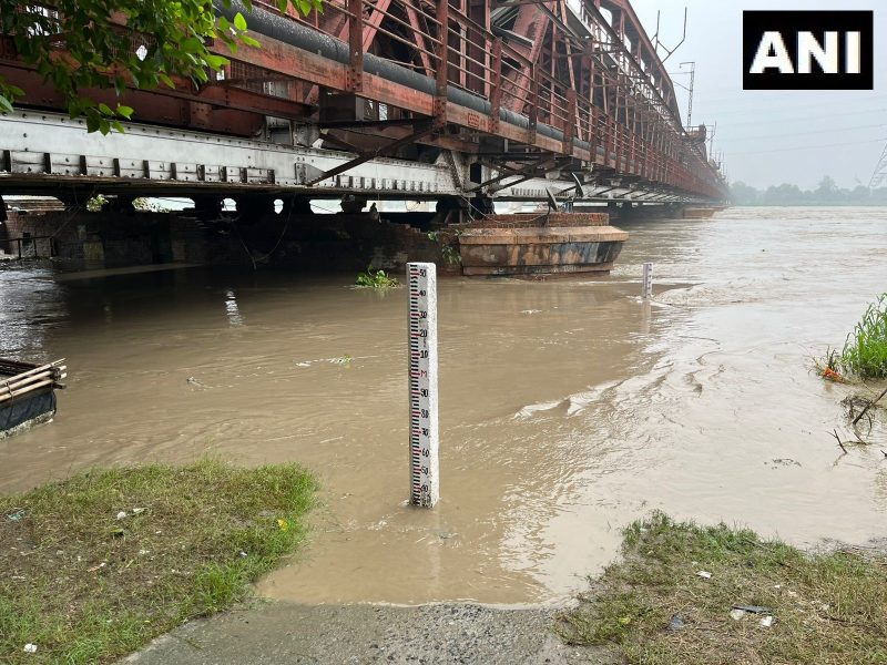
The Yamuna crossed the danger mark of 205.33 metres in Delhi on Monday (July 10) evening, much earlier than anticipated. According to the Central Water Commission’s (CWC) flood-monitoring portal, the water level at the Old Railway Bridge rose to 206.28 metres by 6 am on Tuesday (July 11) with Haryana releasing more water into the river from the Hathnikund barrage in Yamunanagar.
Addressing a press conference on Monday, Chief Minister Arvind Kejriwal said a flood-like situation was unlikely in Delhi, but the city government was prepared to tackle any eventuality.
#WATCH | Water level of River Yamuna continues to flow above the danger level in Delhi's Old Railway Bridge area. Railway and traffic movement on the Bridge has been stopped.
At 8 am today, water level of River Yamuna recorded at 206.32 metres at Old Railway Bridge. The highest… pic.twitter.com/sn4FGWQp9H
— ANI (@ANI) July 11, 2023
He said the evacuation of people from low-lying areas would begin once the river breached the 206-metre mark.
An official from East Delhi district said the evacuation process began on Monday night after floodwaters entered some areas. “Only those living in the affected areas have been shifted to camps on higher grounds,” he said.
Watch: Monsoon wreaks havoc up North; Delhi on flood alert as Yamuna crosses the warning mark
According to the irrigation and flood control department, the flow rate at the Hathnikund barrage had shot up to the 3 lakh-cusec mark on Monday.
Normally, the flow rate at the barrage is 352 cusecs, but heavy rainfall in the catchment areas increases the discharge. One cusec is equivalent to 28.32 litres per second.
Water from the barrage takes around two to three days to reach Delhi.
Northwest India has seen incessant rainfall over the last three days, with many areas in Jammu and Kashmir, Uttarakhand, Himachal Pradesh, Haryana, Uttar Pradesh, and Rajasthan recording “heavy to extremely heavy” precipitation.
This has resulted in overflowing rivers, creeks and drains that have massively damaged infrastructure and disrupted essential services in Jammu and Kashmir, Himachal Pradesh, Uttarakhand, and Punjab.
Delhi recorded its highest rainfall (153 mm) in a single day in July since 1982 in the 24-hour period ending at 8:30 am on Sunday. The city received an additional 107 mm rainfall in the subsequent 24 hours, exacerbating the situation.
The heavy rain transformed roads into gushing streams, parks into watery labyrinths and marketplaces into submerged realms.
#WATCH | Delhi: PWD (Public Works Department) Minister Atishi inspects Yamuna River pic.twitter.com/FVhJToBcqv
— ANI (@ANI) July 10, 2023
In response to the torrential rain, the Delhi government announced a closure of all schools on Monday and cancelled the Sunday leave of government officials, instructing them to be in the field.
Also read: Rat fever in monsoon: What it is, how it is caused, and how you can prevent it
The Yamuna river system’s catchment covers parts of Uttar Pradesh, Uttarakhand, Himachal Pradesh, Haryana, Rajasthan, Madhya Pradesh, and Delhi.
The low-lying areas near the river in Delhi are considered prone to flooding and are inhabited by around 41,000 people.
Encroachments on the river floodplain have occurred over the years, despite the land belonging to the Delhi Development Authority (DDA), revenue department and private individuals.
The Yamuna breached the danger mark twice in September last year, with the water level reaching 206.38 metres.
In 2019, the river witnessed a peak flow rate of 8.28 lakh cusecs on August 18-19 and the water level rose to 206.6 metres. In 2013, it reached a level of 207.32 metres.
The river had swollen to a record water level of 207.49 metres in 1978.
(With agency inputs)

