







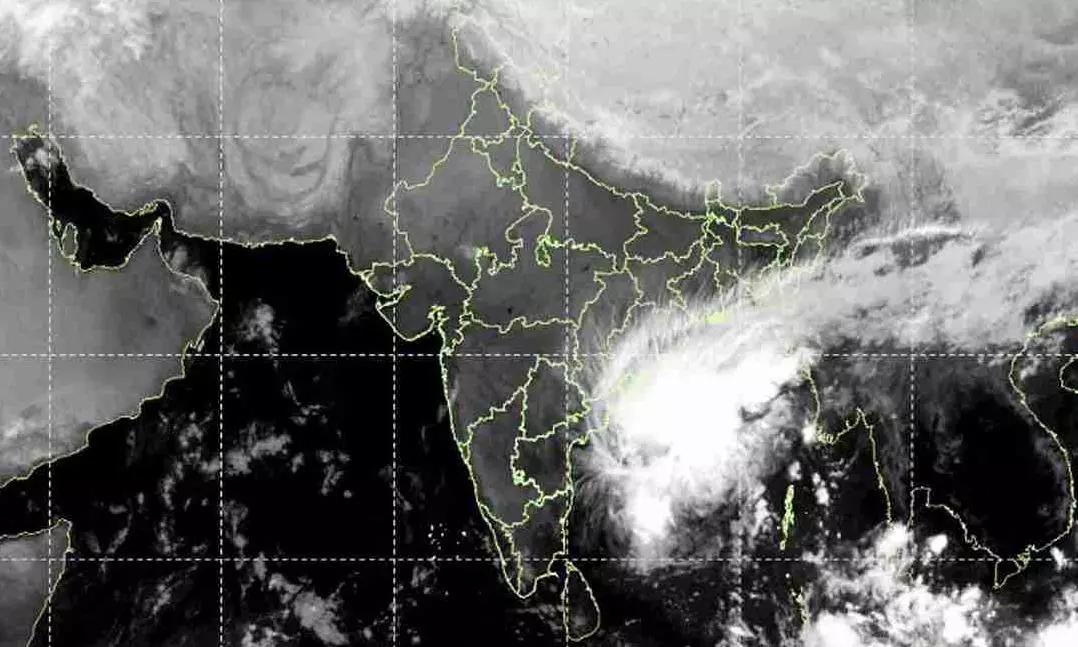
Andhra, Odisha brace as Akvan turns ‘severe’, may not become ‘very severe’
Akvan strengthens over Bay of Bengal as Andhra Pradesh prepares for landfall and Odisha readies evacuation of over 2 lakh people

Cyclone Akvan intensified into a severe cyclonic storm over the central parts of the south and adjoining west-central Bay of Bengal early on Wednesday (November 18), prompting heightened alerts across Andhra Pradesh and Odisha.
The India Meteorological Department (IMD) issued an orange alert for the Andhra Pradesh and adjoining south Odisha coasts as the system continued moving north-northwestwards at around 3 kmph. At 5.30 am on November 18, the cyclone was centred about 580 km east of Chennai, 610 km southeast of Machilipatnam, 610 km south-southeast of Visakhapatnam, and 730 km south of Gopalpur.
May not become ‘very severe’ storm
The IMD said it is likely to continue moving north-northwestwards and cross the Andhra Pradesh and Yanam coast between Nellore and Visakhapatnam around noon on November 20 as a severe cyclonic storm, packing sustained winds of 100-110 kmph and gusts up to 120 kmph.
Also read: Back-to-back severe cyclones: How common is it in Bay of Bengal?
The latest bulletin marks a shift from earlier forecasts, when Akvan was expected to intensify first into a severe cyclonic storm and later into a very severe cyclonic storm before making landfall. However, the latest IMD update now projects landfall as a severe cyclonic storm, while maintaining warnings of heavy rainfall and strong winds along the Andhra Pradesh coast.
As Cyclone Akvan gathers strength over the Bay of Bengal, authorities in both Andhra Pradesh and Odisha are racing to complete evacuations, secure infrastructure and disseminate warnings, hoping to minimise the impact of what is expected to be the region’s third major cyclone threat in recent weeks.
Andhra braces for impact
With memories of recent cyclones Arnab and Murasu still fresh, Andhra Pradesh has intensified preparedness measures. Chief Minister N Chandrababu Naidu has directed officials to continuously disseminate weather alerts in vulnerable areas, clear uprooted trees and damaged electric poles promptly, and ensure residents stay away from breached tanks, canals and other hazardous locations.
Heavy rainfall is forecast across parts of coastal Andhra Pradesh over the next several days. Districts including Srikakulam, Vizianagaram, Visakhapatnam, Alluri Sitharama Raju, Kakinada, East and West Godavari, Krishna, Bapatla, Nellore and adjoining regions are expected to receive significant rainfall, accompanied by thunderstorms, lightning and gale-force winds. The IMD has advised a complete suspension of fishing operations, warning that sea conditions are likely to remain extremely rough.
Also read: Cyclone Murasu wreaks havoc in Andhra
The South Coast Railway Zone has also stepped up preparedness. General Manager Sandeep Mathur reviewed safety arrangements and directed officials to remain fully prepared for any cyclone-related disruption, with particular emphasis on passenger safety and protection of railway infrastructure.
Odisha wary of landslides
Neighbouring Odisha has launched a large-scale preparedness exercise despite the cyclone being forecast to make landfall further south. The state government plans to shift more than two lakh people from vulnerable locations, particularly in landslide-prone hilly districts, as a precautionary measure.
Disaster Management Minister Suresh Pujari said landslides had emerged as a major concern following Cyclone Arnab, during which most fatalities in the state were linked to landslide incidents. Six districts — Ganjam, Gajapati, Rayagada, Kandhamal, Malkangiri and Koraput — have been identified as highly vulnerable.
The state has mapped 1,902 vulnerable locations across 87 blocks and identified more than 2.04 lakh people who may require evacuation if conditions deteriorate. Authorities have earmarked 3,329 cyclone shelters, deployed ODRAF and NDRF teams, distributed satellite phones to districts and directed telecom operators to ensure backup connectivity and rapid restoration plans.
The Odisha government has also coordinated with the Coast Guard and railway authorities, while warning fishermen not to venture into the sea between November 18 and November 20. IMD officials said Odisha is likely to experience more rainfall than damaging winds, with precipitation expected to intensify between November 19 and 20.
(With agency inputs)