







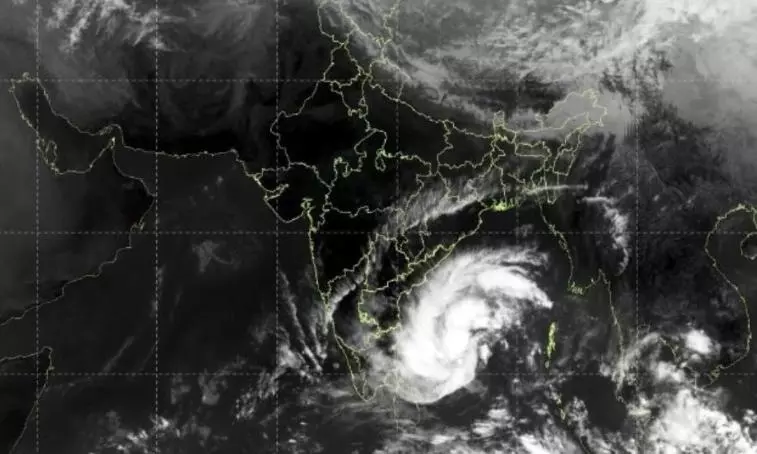
Cyclone Akvan set for Andhra landfall as ‘very severe’ storm; Odisha, TN brace for rain
With losses already exceeding Rs 7,000 cr from two cyclones, Andhra on alert as Akvan heads for likely landfall this week; Odisha prepares for evacuations

Cyclone Akvan is likely to cross the Andhra Pradesh coast as a very severe cyclonic storm around Friday (November 20) noon, the India Meteorological Department (IMD) said on Monday (November 16).
Andhra is already reeling under two back-to-back severe cyclones, Arnab and Murasu. On Sunday (November 15), Chief Minister N Chandrababu Naidu sought immediate financial assistance from the Centre for relief and rehabilitation measures following Cyclone Murasu on November 2-3, which caused an estimated damage of Rs 2,484.43 crore. Less than a week before that, Cyclone Arnab on October 28 caused an estimated Rs 4,600 crore in losses to the state, according to preliminary figures shared by Naidu.
Third cyclone in less than 3 weeks
The Akvan system is currently a deep depression over the southeast and adjoining southwest Bay of Bengal and is likely to intensify into a cyclonic storm by this evening. It is further projected to develop into a severe cyclonic storm by Tuesday (November 17), before strengthening into a very severe cyclonic storm around the night of November 19, the IMD said in its latest update.
Also read: COP31 in Antalya: Big polluters and climate activists under one roof
The storm is likely to cross Andhra Pradesh and Yanam coasts between Nellore and Tuni by noon on November 20, with the maximum sustained wind speed of 120–130 kmph gusting to 145 kmph. For comparison, Cyclone Arnab made landfall with sustained wind speeds of 125–135 kmph, gusting up to 150 kmph), while Cyclone Murasu crossed the coast with slightly lower winds of 100–110 kmph, gusting up to 120 kmph.
Odisha begins preparations for evacuation
Odisha, which also suffered losses, including deaths, during the previous two cyclones, has directed district administrations in the southern region to initiate early evacuation of people from vulnerable areas ahead of the expected heavy rainfall.
Ganjam Collector Keerthi Vasan V said the administration had identified landslide-prone locations and low-lying areas susceptible to inundation. “There are hilly areas and low-lying places across Ganjam district. Men and machinery are ready to begin shifting people well before the rains,” Vasan told reporters.
He said preventing casualties, particularly in landslides, would be a priority. At least 11 people were killed and six remained missing in Odisha during Cyclone Arnab. Ten of the deaths were reported in landslides in Ganjam and Kandhamal districts.
Odisha rainfall and wind warning
According to the IMD, Odisha is likely to receive light to moderate rainfall at many places from the evening of November 17, with heavy rainfall at isolated locations on November 18. Heavy to very heavy rainfall is forecast at isolated places between November 19 and 21.
Squally winds with speeds of 40-50 kmph, gusting to 60 kmph, are likely along and off the Odisha coast on November 18. Wind speeds could increase to 50-60 kmph, with gusts reaching 70 kmph, from November 19 until the morning of November 20.
The sea is also expected to remain rough to very rough from November 18 until the morning of November 20. Fishermen have been advised not to venture into the sea during this period.
Heavy rain forecast for Chennai, neighbouring districts
Tamil Nadu, which has remained largely dry this northeast monsoon season, can expect to experience spells of heavy rainfall as the weather system intensifies.
The IMD has forecast heavy rain accompanied by thunderstorms and lightning in Chennai, Tiruvallur and Chengalpattu from November 17. Gusty winds reaching speeds of 40-50 kmph are also likely in these districts.
Also read: ‘Super El Nino’ could put over 450,000 lives at risk from extreme heat
From November 18, heavy rainfall is expected in Kanchipuram, Ranipet, Tiruvannamalai, Villupuram, Cuddalore and Mayiladuthurai districts, as well as Puducherry.
Chennai and several other parts of Tamil Nadu had already received moderate rainfall in the 24 hours ending at 5.30 am on Monday. Tuticorin recorded the highest rainfall during this period at 20 mm, followed by Nagercoil and Kanyakumari, which received 10 mm each. The Nilgiris and Virudhunagar districts also reported moderate rain.
The IMD has advised fishermen along the Tamil Nadu coast not to venture into the sea between November 16 and 21.
Current location of cyclone
In its latest bulletin issued, the IMD said the Akvan system was located approximately 720 km east-southeast of Chennai, 820 km south-southeast of Visakhapatnam, 940 km south of Gopalpur in Odisha, about 680 km west of Sri Vijaya Puram in the Andaman and Nicobar Islands.
The IMD has issued a pre-cyclone watch for the Andhra Pradesh and adjoining south Odisha coasts, placing the regions under a yellow message.
(With agency inputs)