
- Home
- India
- World
- Premium
- THE FEDERAL SPECIAL
- Analysis
- States
- Perspective
- Videos
- Sports
- Education
- Entertainment
- Elections
- Features
- Health
- Business
- Series
- Bishnoi's Men
- NEET TANGLE
- Economy Series
- Earth Day
- Kashmir’s Frozen Turbulence
- India@75
- The legend of Ramjanmabhoomi
- Liberalisation@30
- How to tame a dragon
- Celebrating biodiversity
- Farm Matters
- 50 days of solitude
- Bringing Migrants Home
- Budget 2020
- Jharkhand Votes
- The Federal Investigates
- The Federal Impact
- Vanishing Sand
- Gandhi @ 150
- Andhra Today
- Field report
- Operation Gulmarg
- Pandemic @1 Mn in India
- The Federal Year-End
- The Zero Year
- Science
- Brand studio
- Newsletter
- Elections 2024
- Events
- Home
- IndiaIndia
- World
- Analysis
- StatesStates
- PerspectivePerspective
- VideosVideos
- Sports
- Education
- Entertainment
- ElectionsElections
- Features
- Health
- BusinessBusiness
- Premium
- Loading...
Premium - Events

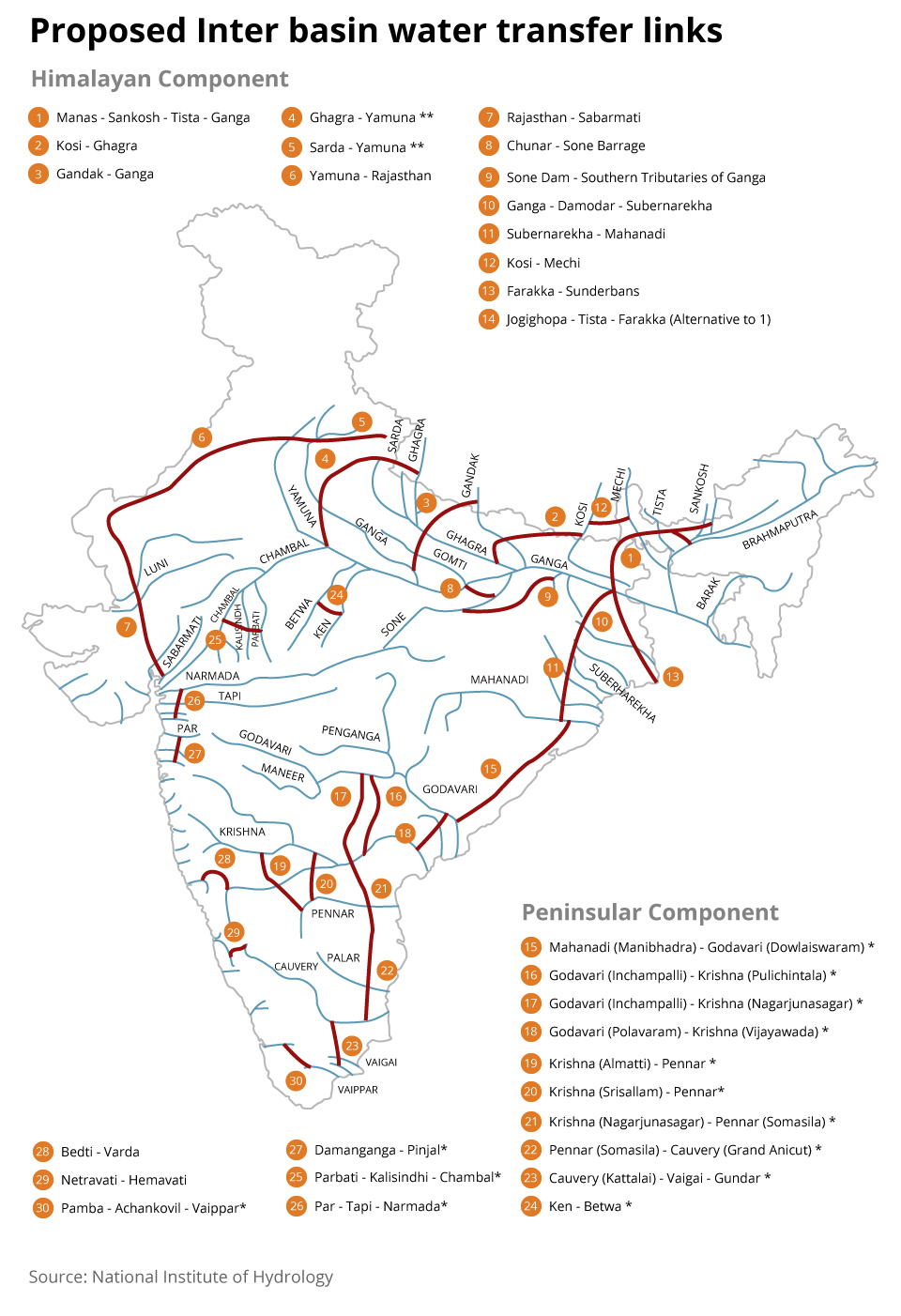
River linking: Good in logic, bad in science
The idea to link peninsular rivers dates back to the late 19th century, when the acclaimed British-era engineer Arthur Cotton drew up plans to connect them

Nitin Gadkari’s tweet about how the newly-elected NDA government’s priority is to link rivers Krishna and Godavari and bring the surplus to the historically water deficit state of Tamil Nadu strengthened the ever-present hum about river interlinking in the state. While the feasibility reports prepared by the National Water Development Agency (NWDA) for interlinking...
Nitin Gadkari’s tweet about how the newly-elected NDA government’s priority is to link rivers Krishna and Godavari and bring the surplus to the historically water deficit state of Tamil Nadu strengthened the ever-present hum about river interlinking in the state.
While the feasibility reports prepared by the National Water Development Agency (NWDA) for interlinking of Mahanadi-Godavari-Krishna-Pennar-Palar-Cauvery-Vaigai-Gundar rivers assure 214 tmcft of water, a research paper published in 2016, based on work conducted by IIT Madras and IIT Bombay, concluded that the river basins in question have been receiving decreased rainfall over the years. It is to be noted that the dataset which was used to conclude this is spread over 103 years (from 1901 to 2004) and a spatial spread of 1,384 Indian Meteorological Department weather stations across India.
The idea to link peninsular rivers dates back to the late 19th century, when the acclaimed British-era engineer Arthur Cotton drew up plans to connect them, with the motive to improve inland navigation. After Independence, buoyed by Mao’s persistence to tame rivers in China and examples from the Soviet Union and the United States, the concept of flood management in the Indian subcontinent led to the idea of linking river basins to transfer the surplus water.
The National Water Grid proposed by KL Rao was based on the principle that the Ganga and Brahmaputra basins are water surplus, while peninsular and southern India are water deficit. It is this thought that led to the formation of the National Water Development Agency in 1982 under the Ministry of Water Resources during Indira Gandhi’s tenure to study the feasibility of linking rivers.
Water surplus and deficit
It is to be noted that the peninsular rivers depend on monsoons to sustain their flow, in comparison to the perennial rivers in the north and east. While this adds credence to the idea of transferring surplus from north to the south, the dynamics of the monsoon that determines the destiny of the peninsular rivers tells us a different story that puts a question mark on the proposal to link the Godavari, Krishna and Cauvery.
Government documents on river interlinking reveal the difference between the Godavari and Krishna basins. While the Godavari basin is considered ‘water surplus’, Krishna is considered ‘water deficit’. Here, it is the jargon — ‘water surplus’ and ‘water deficit’ — that requires clarification, as doubt is cast upon the technique which is adopted to classify a basin as ‘surplus’ or ‘deficit’.
One of the key findings from the 2016 paper about the river basins and rainfall in India — the hypothesis that “wet regions get wetter and dry regions get drier” due to climate change — does not hold good for India. The outcome of the analysis has cast doubt on whether the ‘water-surplus’ basins will remain ‘surplus’ in response to changing climatic conditions. With peninsular rivers primarily receiving their water from monsoon, the uncertainty associated with the monsoon definitely puts such classification under question. It is on this basis that the paper called for re-evaluation of planning for river-interlinking to supply water from surplus to deficit regions.
The uncertainties associated with monsoon, along with the impact of human intervention on the flow of these rivers, are largely unknown, which raise questions on the ecological and financial implications.
In addition to that, the zeal to control floods and the oft-repeated thought that hundreds of cusecs are getting wasted by flowing into the sea bring us to the question of whether we as a society have internalised the role of floods in sustaining the ecosystem along a river’s flow and the health of coastal ecosystem.
Freshwater dependence
This leads us to the term ‘environmental flow requirements’. Freshwater-dependent ecosystems provide a range of services to humans including fish, flood protection, preventing soil erosion, and wildlife. To maintain these ecosystems, water needs to be allocated alike for agriculture, power generation, domestic, and industry use. At the same time, there are difficulties around quantifying the water requirements for the freshwater-dependent ecosystems, given the lack of understanding of the various physical processes and the interactions between the various components of the ecosystem.
It is also to be noted that the environmental flow requirement is not a cumulative number, say for a period of one year, but a suite of flow discharges of certain magnitude, timing, frequency and duration. These flows ensure a flow regime capable of sustaining a complex set of aquatic habitats and ecosystem processes.
Moreover, it is stated that nearly all sediments are likely to be trapped in existing reservoir systems in Srisailam and Nagarjunasagar, which plays a major role in coastal erosion in Krishna delta. It is said that this upstream flow regulation along with human activities like conversion of cropland and mangrove areas to aquaculture ponds may be responsible for sea transgression, leading to coastal erosion and shoreline retreat of deltas. The term ‘closed basin’ is used to denote the basin associated with river Krishna as only occasional overflows in the river spill into the delta, contributing almost zero sediment to it. The already existing reservoirs on Krishna are said to have a long-lasting detrimental effect on the delta and its agricultural productivity.
The utilitarian mind would wish to look at rivers purely from a plain-dweller mindset that seems to dominate the vocal sections of civil society, wherein the path that a river takes from mountains to the plains is seen as a sterile conduit for water akin to the concrete covered canals and channels which they see around. On the other hand, rivers are natural channels for water carry various nutrients and minerals. They modify local microclimates, including temperature and humidity. Any large scale change in their course will eventually change the patterns in which these environmental entities flow and shape the existing local and regional climate systems.
Coastal ecosystems are vulnerable
It is here the statement in the memorandum sent by a group of concerned citizens to Prime Minister Atal Bihari Vajpayee on April 22, 2003 assumes more importance. “Where a river linking or long-distance water transfer proposal seems prima facie a good option, (it will be good to) get a thorough, professional feasibility report prepared in a fully interdisciplinary manner, internalizing not merely the techno-economic but also the environmental, human, social, equity, ‘gender’ and other relevant aspects and concerns and put it through a comprehensive, interdisciplinary, rigorous and stringent process of detailed examination, appraisal and approval,” it says.
Increasing reliance on fertilizers to ensure sustained food production in the face of declining soil productivity, coupled with the incentive structure in place, which nudges farmers to produce crops that are not in line with the water availability in the region, puts the health of the delta and coastal ecosystem at risk. This negatively impacts the resilience of water security, rather counter intuitively.
Also read: For waterman, Ganga is so holy yet unholy
In the paper published in 2018, the authors argue that increasing water supply enables higher water demand, which can quickly offset the initial benefits of reservoirs. Moreover, they contemplate that over-reliance on reservoirs increases vulnerability, and increases the potential damage caused by drought.
The least spoken about community in the debate on river interlinking is the coastal community — the ecosystem they depend on thrives on the nutrients brought in by rivers from the mountains and plains. The lack of sediments, in addition to river sand mining, directly impacts the productivity of coastal waters and endangers the delta.
In an opinion piece for Scroll, writers John Kurien and Nandakumar D clearly state: “A wise water policy for India requires the merger of a coastal seascape perspective and a landscape perspective. The integrated river basin concept attempts to make the landscape perspective more holistic. To this, we need to add concepts that connect the dynamics of the coastal seascape to stocks and flow of water from the landscape. This will be an important starting point to fashion a water policy that will adequately cover the concerns of coastal ecology, the sustainable livelihoods of coastal communities and the future of other coastal zone populations.”
It’s time for the mountains and oceans to talk with land as equals, where the land attempts to understand their language, without imposing the language of the plains on them.