
Idukki dam: How Kerala’s prized asset sometimes turns fiend
The Idukki reservoir forms the backbone of the Periyar hydropower network, but its flooding causes extensive damage

Folklore has it that the Idukki dam ended a curse. It is said that when Lord Rama and Sita rested in the area on their way back to Ayodhya, tribal couple Kuravan and Kurathi chanced to see Sita taking a bath in River Periyar. An angry Rama turned them into granite hills Kuravanmala and Kurathimala. As the couple pleaded for mercy, Rama said they would attain salvation when they were joined together. So, when the Idukki dam was built over the narrow gorge between the two hills, the locals believed it was the end of the curse on the mythical couple.
Since its commissioning in 1976, the Idukki dam has indeed proved a blessing for the nearby districts, providing water for irrigation as well as power generation. And yet, as the lynchpin of the Periyar river basin, it is also among Kerala’s biggest challenges when monsoon strikes.
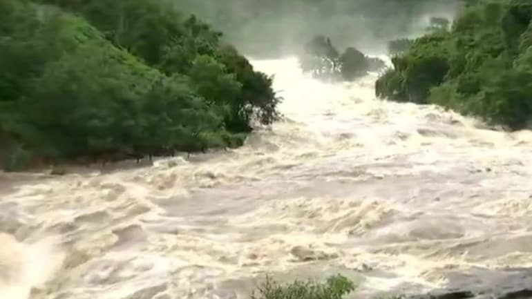
As the state government opened the shutters of the Idukki reservoir at 11 am on Tuesday — for just the fifth time in history — the predominant sentiment was one of foreboding. After all, less than three years ago, flooding in the region had caused nearly 500 fatalities and severe damage to property. (The reservoir shutters were earlier opened in October 1981, October 1992, and twice in 2018, in August and October.)
Also read: Govt releases water from reservoirs as rains continue to lash Kerala
While the state tends to face the crux of monsoon fury due to its geographic position in the south-west tip of the peninsula, a large part of the problem are the dams, particularly Idukki. What is it about Idukki — its structure, topography and politics — that makes it so critical to the state’s wellbeing?
Unique structure
At 168.91 m, the Idukki dam, constructed and owned by the Kerala State Electricity Board (KSEB), is one of Asia’s highest arch dams, and India’s first. Along with the Cheruthoni and Kulamavu dams, it creates a 60 sq km artificial lake. The double curvature arch dam, said to be earthquake-resistant, is estimated to have a life of 300 years. It supports a 780 MW hydroelectric power station.
The Idukki dam is designed to hold over 2,400 feet of water. The effective storage capacity of the Idukki reservoir is 1,460 MCM. The Idukki and Idamalayar reservoirs together store 21.3% of the total annual flow of the Periyar, which tends to collect copious amounts of rain water from the southwest monsoon. Idukki, therefore, is critical to Kerala’s flood hazard management programme.
Interestingly, the Idukki dam doesn’t have any shutters of its own. Therefore, when water levels in the reservoir reach hazardous levels, it’s the Cheruthoni dam whose shutters are opened to let water into the Periyar and manage the spillage.
The full reservoir level (FRL) of the Idukki dam is 2,403 feet. A blue alert was issued late last week when the level reached 2,390.86 ft. Once it crossed 2,396 feet, an orange alert was issued. On Monday, the government issued a red alert. On Tuesday morning, the water level in the dam reached 2,398.04 ft, leading the authorities to open the shutters.
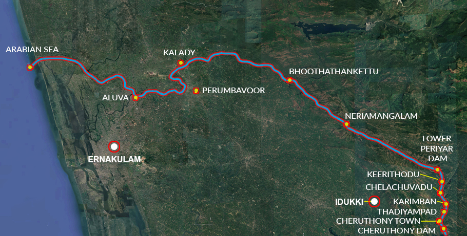
Where the water flows
Once the shutters are opened, the water spills into River Cheruthoni first. From there, it travels to Vellakayam and subsequently merges with the Periyar.
Thereupon, the water goes to Thadiyampad, Karimpan Causeway, Chelachuvadu, Keerithodu, Plamba forest area, lower Periyar dam, Neriamangalam, Bhoothankettu, Idamalayar, Malayatoor, Kalady, Aluva, Chengamanad, Eloor, Varapuzha, Manjaly and Chendamangalam.
Further, the water flows to areas in western Kochi, including Vallarpadam, Panambukad, Mulavukadu and Ponnarimangalam. At the end of the journey, the water enters the Arabian Sea through the Vembanad backwaters at one end, and via the Kottapuram backwaters.
Between 2018 and now
The debate still rages on how much of Kerala’s 2018 floods were attributable to excess rains caused by global warming, and how much to inefficient dam management. Studies conducted by hydrology experts from IIT-Madras, IIT-Gandhinagar and Purdue University in the US reportedly concluded that it was caused by unusually heavy monsoon rains. The dam water release strategy had little to do with the extensive damage, they postulated.
However, the Kerala High Court-appointed an amicus curiae, advocate Jacob P Alex, who lay the blame on poor dam management. The nearly 80 dams in the state were focused on hydro power generation, with little effort taken for flood control, he argued.
The Pinarayi Vijayan government was widely accused of delayed action in opening the Idukki reservoir gates in 2018, leading to extensive damage. Three years hence, it sought to allay such criticism. The opening of the dams was carried out in a phased manner with adequate warning and careful evacuation plans.
Damage control
Water Resources Minister Roshi Augustine was quoted as saying two shutters of Idukki dam would be opened by 50 cm to release 1 lakh litres of water a second. “The decision was taken considering the experiences of the past,” he reportedly said. [The Idukki dam does not not have shutters. The water is let out of the Idukki dam by opening the shutters of the Cheruthoni dam].
The Kerala government is also keeping a weary eye on the economics of dam management. In 2018, it had opened all the five shutters of the Idukki reservoir in phases and maintained that position for about a month, said media reports. This led to an equivalent loss of 1,500 mu of generated power. Now, the KSEB is going for a staggered release to contain the power generation loss.
