Cyclone Bulbul to bring heavy rain; Odisha, Bengal brace to handle calamity

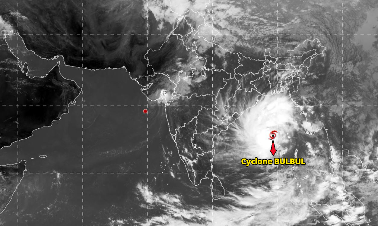
With cyclone Bulbul set to intensify into a “very heavy cyclonic storm” on Friday (November 8), the India Meteorological Department in its latest bulletin on Thursday (November 7) night predicted heavy rains in several parts of Odisha and West Bengal.
According to ANI, the cyclone at 5.30 am on Friday was centred about 530 km south-southwest of Sagar Islands in the Bay of Bengal and is expected to cross West Bengal and Bangladesh coast across Sundarbans Delta in the early hours of November 10.
The weatherman on Thursday had said that the cyclone is likely to move initially north-northwestwards and then nearly northwards till November 9.
It will then re-curve northeastwards towards Bangladesh and adjoining West Bengal, skirting Odisha, and cause heavy to very heavy rain in the coastal districts of North Odisha and West Bengal for three days from Friday.
Also read: A year after Titli & Luban, 2 cyclones developing in 2 seas put 4 states on alert
With the department predicting heavy to very heavy rainfall in north coastal districts of Odisha on November 8 and 9 and extremely heavy rainfall in the coastal districts of West Bengal on November 9, the governments of the two states are taking measures to ensure that damage from the storm is contained, even as the Centre assured them of all assistance.
Taking note of the severity of the storm and possibility of damage to property and lives, the Centre has asked the West Bengal and Odisha government to take all steps to deal with Bulbul and ensure there is minimum casualty and damage.
The weatherman predicted possible damage to thatched roofs, embankments and roads in the coastal districts of North Odisha and West Bengal. It advised people in affected areas to remain indoors and total suspension of fishing from November 8.
According to the I & PR department of Odisha, heavy rainfall has been predicted in nine districts of the state – Puri, Khordha, Cuttack, Jagatsinghpur, Kendrapara, Jajpur, Bhadrak, Balasore and Mayurbhanj.
To handle any eventualities, two teams of Odisha Disaster Rapid Action Force (ODRAF) each have been dispatched to these districts. The government has also announced that cyclone shelters will be fully operational in these districts and schools will be closed till November 9.
In Bhubaneswar, Special Relief Commissioner (SRC), PK Jena said as per IMD predictions, coastal Odisha is likely to experience wind speed of 70-80 kmph gusting up to 90 kmph on
Friday accompanied by heavy to very heavy downpour.
However, the Met departments forecast that the cyclone may skip Odisha has come as a major relief to the people of the state, who are still struggling to return to normalcy post cyclone Fani in May that had claimed more than 64 lives and destroyed around five lakh houses.
At a high-level meeting in New Delhi, Principal Secretary to the Prime Minister, PK Mishra also assured the states of all necessary central assistance. The meeting was convened in the wake of concern expressed by Prime Minister Narendra Modi. Top officials of Odisha, West Bengal and Union Territory of Andaman and Nicobar Islands attended the meeting
through video conference.
The Met said sea condition will be rough to very rough along and off Odisha and West Bengal coasts from Friday onwards and will become very high on Saturday and Sunday.
In West Bengal, fishermen have been advised to return to the coast by Thursday evening and not venture into the seas till the caution is lifted. District officials have been asked to keep a tab on the situation and prepare for any contingency, a government functionary said.
The weatherman has forecast sustained windspeed of 120 to 130 km per hour with gusts of up to 140 kmph when the cyclone will be at its very severe form on Friday and then lessen to a severe cyclonic storm on November 9.
Under its impact, heavy to very heavy rainfall with extremely heavy rain at one or two places is likely to occur in the coastal districts of North and South 24 Parganas on November 9 and 10, the Met said.
It will also bring heavy rain in Kolkata East and West Midnapore, Howrah, Hooghly and Nadia district during the two days.
(With inputs from agencies)


