Nepal house clears map change, India wants talks to resolve issue
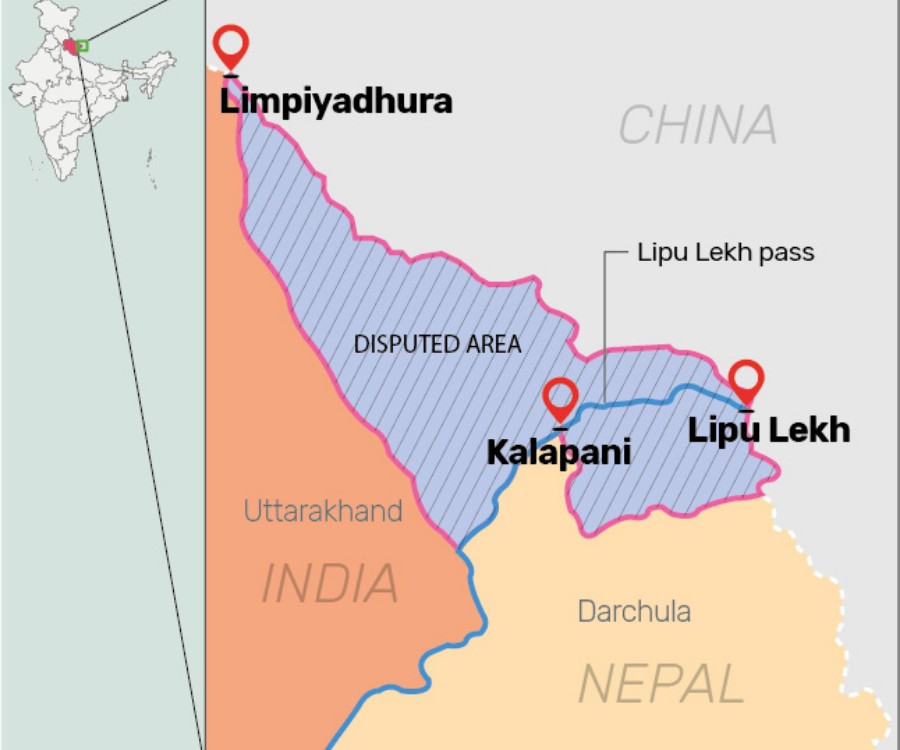
Nepal Parliament's special session began on Saturday (June 13) to discuss a key Constitution amendment bill tabled by the government to revise the country's political map, laying claim over the strategically key areas of Lipulekh, Kalapani and Limpiyadhura along the border with India.

Nepal Parliament’s lower house on Saturday (June 13) unanimously voted to amend the Constitution to update the country’s new map, laying claim over the strategic areas of Lipulekh, Kalapani, and Limpiyadhura along the border with India. The unanimous decision of the lower house will now pave way for the Nepal government to expedite the process to replace the political map in Nepal’s national emblem.
However, India’s Ministry of External Affairs has responded to Nepal parliament’s decision, saying that the artificial enlargement of claims is not based on historical fact or evidence. It is also violative of the current understanding to hold talks on outstanding boundary issues.
This artificial enlargement of claims is not based on historical fact or evidence and is not tenable. It is also violative of our current understanding to hold talks on outstanding boundary issue: Ministry of External Affairs https://t.co/tW9jfddhwW
— ANI (@ANI) June 13, 2020
Opposition parties including the Nepali Congress (NC), Rastriya Prajatantra Party (RPP), and the Rastriya Janata Party-Nepal (RJP-N) also voted in favour of the government bill to amend Schedule 3 of the Constitution for updating the national emblem, by incorporating the new controversial map.
Speakar Agni Sapkota announced that all the 258 lawmakers who were present in the house voted in favour of the amendment bill and there was zero vote against it. The amendment proposal has been passed in the parliament with more than two-thirds majority. A two-thirds majority was necessary in the 275-member House of Representatives or the lower house to pass the bill.
Nepal Parliament’s special session began on June 13 to discuss a key Constitution amendment bill tabled by the government to revise the country’s political map, laying claim over the strategically key areas of Lipulekh, Kalapani, and Limpiyadhura along the border with India.
Meanwhile, Indian Army Chief M M Naravane had stated that the India-Nepal border situation is under control and also expressed hope that the ongoing dialogue will settle the perceived differences.
“We have a very strong relationship with Nepal. We have geographical, cultural, historical, religious linkages. We have very strong people-to-people connect. Our relation with them has always been strong and will remain strong in the future,” Gen Naravane said.
He was speaking to reporters on the sidelines of the passing out parade of the Indian Military Academy.
The House of Representatives opened the discussion on the amendment bill which will be put for voting after the deliberations are over, said spokesman at the Parliament Rojnath Pandey.
Related news: Amid border dispute, Nepal govt to clear new map which includes Indian territory
Now that the bill is passed by the Lower House, it will be sent to the National Assembly where it will undergo a similar process.
The NA will have to give lawmakers 72 hours to move amendments against the bills provisions, if any.
After the National Assembly passes the bill, it will be submitted to the President for authentication, after which the bill will be incorporated in the Constitution.
On June 9, the Parliament unanimously endorsed a proposal to consider the bill to pave way for endorsing the new map.
The government on Wednesday (June 10) formed a nine-member team of experts to collect historical facts and evidence related to the area.
Diplomats and experts, however, questioned the governments move, asking why the task force was formed when the map has already been released and approved by the Cabinet.
Related news: Friends India and Nepal in danger of falling out over 372 sq km of land
The ties between India and Nepal came under strain after Defence Minister Rajnath Singh inaugurated a 80-km-long strategically crucial road connecting the Lipulekh pass with Dharchula in Uttarakhand on May 8.
Nepal reacted sharply to the inauguration of the road claiming that it passed through Nepalese territory. India rejected the claim asserting that the road lies completely within its territory.
Nepal last month released the revised political and administrative map of the country laying claim over the strategically key areas. India has been maintaining that these three areas belonged to it.
India sternly asked Nepal not to resort to any “artificial enlargement” of territorial claims after Kathmandu released the new map.
Prime Minister K P Sharma Oli earlier this month said that his government will seek a solution to the Kalapani issue through diplomatic efforts and dialogue on the basis of historical facts and documents.
“We will get back the land occupied by India through holding a dialogue,” Oli said while responding to questions in Parliament on Wednesday.
Related news: Nepal police detain Indian national, shoot another dead


